Conservation beneath the waves
The Hauraki Gulf/Tīkapa Moana Marine Protection Act is Aotearoa New Zealand’s most significant increase in marine protection in over a decade.
It aims to enhance the health and mauri of Hauraki Gulf/Tīkapa Moana/Te Moananui-a-Toi so we can enjoy clear waters, thriving sea life, and a healthy, resilient ecosystem for generations to come.
Years of pollution, sediment washing in from the land, overfishing, and the growing impacts of climate change have degraded the Gulf environment.
It’s facing depleted shellfish beds, disappearing seagrass meadows and barren reefs overrun with urchins. Marine species are under pressure.
This new Act protects some of the most productive marine areas from human pressures, like fishing, waste dumping and extraction. It is one conservation-led way we can improve this environment.
A decade in the making
The Hauraki Gulf/Tīkapa Moana Marine Protection Act came into effect on 25 October 2025.
This network of marine protection builds on the aspirations of the Sea Change Tai Timu Tai Pari plan. It incorporates feedback from tangata whenua, stakeholders and the public. The Act includes both new and existing marine protection tools.
The protection consists of:
- Two marine reserves – extending from the existing reserves Te Whanganui-o-Hei/Cathedral Cove Marine Reserve and Cape Rodney-Okakari Point (Goat Island/Te Hawere ā Maki) Marine Reserve.
- Twelve high protection areas (HPAs) – these areas protect and restore marine ecosystems. They allow active restoration of the underwater habitat. They also enable authorised customary fishing practices to continue.
- Five seafloor protection areas (SPAs) – these areas protect seafloor habitats from high impact activities. They still allow activities that do not damage them, such as line fishing, spear fishing, diving and harvesting by hand.
The marine protection aims to support tangata whenua in their roles as kaitiaki and rangatira, and acknowledge the cultural value of Tīkapa Moana, Te Moananui-a-Toi.
Marine protection works
In marine reserves around New Zealand we see more types of fish and marine life, larger numbers and larger sizes. This creates a spillover effect into the waters around.
Marine protection in the Hauraki Gulf/Tīkapa Moana has grown from 0.3% to 5.9%. This increase is due to new high-protection areas and extensions to marine reserves, excluding the Cable Protection Zone. This supports the recovery of some of its most biodiverse regions, including its nearshore areas and deep reefs.
The areas were chosen because they meet criteria such as:
- being at-risk
- being rare
- having a large range of diverse wildlife
- representing an important habitat or ecosystem type.
Maps and boundaries
Overview map of all Hauraki Gulf/Tīkapa Moana marine protection areas (PDF, 3,727K)
Maps for each protection area including co-ordinates and GPX files for GPS systems
For tide, boundaries and other information on the go, you can download the MarineMate app.
Consecutive State of our Gulf reports have illustrated that the Gulf is in an ongoing state of environmental decline.
Pollution, sedimentation and climate change have negatively impacted coastal and marine plants and animals.
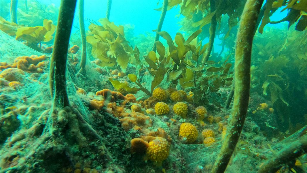
There has also been an increasing amount of kina barrens, habitat loss and localised fisheries depletion.
The new network of protection is designed to protect and restore rare and important habitats. These host a range of different plants and animal life.
Many marine habitats act as a nursery to juvenile fish. Protecting them will help to support fish stocks over time. Some of these habitats are only found in a few remaining areas, like seagrass.
Others, like the complex reef systems around The Noises islands, provide a vital range of habitats to support important species, like mussel beds and shallow sponge gardens.
Marine reserves are areas that are protected from the sea surface to the seafloor. The entire area is strictly 'no take', including marine life, shells, rocks and driftwood.
A range of activities that do not harm marine life are permitted in marine reserves. They include swimming, snorkelling, boating and diving.
Marine reserves would extend from two existing marine reserves:
- Cape Rodney-Okakari Point Marine Reserve (Goat Island). The protected area will nearly quadruple in size. This would protect species such as blue maomao and snapper. More about the marine reserve.
- Te Whanganui-o-Hei/Cathedral Cove Marine Reserve. The protected area will more than double, protecting its hard rock reefs and plants, crustaceans, molluscs and fish. More about the marine reserve.
A high protection area (HPA) aims to protect and restore marine habitats while being flexible to provide for active habitat restoration and the customary practices of tangata whenua. The contributions of tangata whenua representatives have been vital in developing this protection tool.
An HPA protects a selected zone from the surface of the sea to the bottom. This includes the foreshore – the wet part of the beach.
The prohibitions include:
- commercial and recreational fishing – including collecting crayfish and other shellfish
- large-scale removal of non-living materials like sand, stone or driftwood, and
- dumping or discharge of waste, sewerage, or litter.
A permit is required to carry out active restoration activities and other prohibited activities. Visit Activities in the Hauraki Gulf/Tīkapa Moana: Apply for a permit for more information.
Careful anchoring can continue in HPAs.
Active habitat restoration activities, such as removing urchins from urchin barrens, can be allowed, following a permitting process.
Exceptions
Limited commercial fishing is provided for in two of the 12 HPAs -– Rangitoto and Motutapu HPA and Kawau HPA. This is subject to review in three years' time.
This commercial fishing exception is limited to ring-net fishing by operators who ring-net fished in 2021, 2022 and/or 2023, and have an authorisation from DOC. It can only happen between 1 March - 31 August, and can only target kahawai, grey mullet and/or trevally.
These regulations outline further conditions: Hauraki Gulf / Tīkapa Moana Marine Protection (Ring Net Fishing) Regulations 2025.
Authorised customary fishing can continue to occur in high protection areas. This supports Māori cultural knowledge and learning, as well as a cultural guardianship role in the marine area. Customary non-commercial rights are guaranteed under te Tiriti o Waitangi.
Customary non-commercial fishing in high protection areas areas regulated under the Fisheries Act 1996.
Tangata kaitiaki/tiaki (a local guardian or trustee of a specific area) are responsible for managing customary fishing in their rohe moana or area. Tangata kaitiaki are the only people who can authorise customary fishing.
In a high protection area:
- only customary fishing that has written authorisation from a tangata kaitiaki can occur
- the fishing must be for a customary purpose, for example a hui or a tangi.
The small amount of customary fishing that occurs in the Gulf is unlikely to have a significant impact on the conservation goals of the new protection areas.
For more information on customary fishing rights, visit Ministry for Primary Industries – Māori customary fishing information and resources.
Conservation goals will be set for each of the high protection areas and seafloor protection areas.
These goals will help decide what activities can and cannot be permitted in these areas. They will also inform monitoring and research activities.
For high protection areas, additional regulations to manage activities, except customary fishing, could be developed to give effect to these conservation goals for example, regulations limiting anchoring over seagrass.
We are working to set goals for high protection areas in 2027.
A seafloor protection area (SPA) aims to maintain, restore, and protect important seafloor habitats. They protect habitats created by plants and animals (biogenic), such as dog cockles, green lipped mussels, and seagrass beds. Learn more about marine habitats.
These areas limit activities that have a harmful impact on the seafloor, such as:
- commercial, recreational and customary fishing methods that can have a high impact on the sea floor like bottom trawling, dredging, Danish seining
- dumping or discharge of waste, sewarage, or litter
- aquaculture (farming fish or other marine species in the sea – enclosed or otherwise)
- removing sand, and
- mining.
There may be additional restrictions in some of these areas to protect sensitive species.
A permit is required to carry out active restoration activities and other prohibited activities. Visit Activities in the Hauraki Gulf/Tīkapa Moana: Apply for a permit for more information.
All other fishing methods (outside of trawling that touches the seafloor, dredging, and Danish seining) can continue in SPAs. This means:
- you can dive for seafood
- you can go spear fishing
- you can go line fishing
- careful anchoring can continue in SPAs.
A seafloor protection area protects habitats created by plants such as seagrass beds and animals such as dog cockles and green lipped mussels. Learn more about marine habitats.
DOC has a team of marine rangers dedicated to managing marine reserves, high protection areas and seafloor protection areas in the Hauraki Gulf/Tīkapa Moana. These rangers use vessels based in Warkworth, Auckland’s North Shore and Whitianga.
Their role includes educating people on the new protection areas and rules, undertaking compliance, and monitoring changes in the underwater habitat.
From October 2025, the team will be installing signage at boat ramps and entry points, distributing protection area maps to fishing retailers and supporting commercial chart-plotter companies to add the new boundaries to their systems.
There will be summer rangers at key marine reserves, HPAs and boat ramps from early December to support the educative focus during summer.
Compliance will gradually build to support the educative focus. This will include both on-the-water patrols and the use of drones and high zoom CCTV cameras to monitor activity in these protection areas.
Wildlife systems in Hauraki Gulf/Tīkapa Moana are large and complex. Some habitat types may respond to increased protection within 1 to 2 years. Others could take longer.
There are also pressures on the Gulf that will continue despite the new protection areas, such as pollution and climate change.
DOC will monitor the new protection areas and use of these tools to see if they are working. This will allow us to adjust to changes or other pressures when needed.
The protection areas are only one part the Revitalising the Gulf plan. Others are being rolled out, including fisheries measures, work to restore natural habitats and address land-based impacts.
All of these actions are required to reverse the decline in the Hauraki Gulf/Tīkapa Moana. It will take several years to put in place and to take effect.
- Regulatory Impact Statement (PDF, 5,912K)
- Technical analysis of the plan’s marine protection proposals (PDF, 7,521K)
- Technical analysis of the plan’s protected species proposals (PDF, 1,172K)
- Indicative geospatial files for the plan's marine protection proposals (ZIP, 755K)
- Evaluation of biodiversity protected by Sea Change Tai Timu Tai Pari – Marine Protected Area proposals (DOCX, 12,418K)
- See other Revitalising the Gulf work programmes