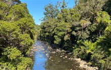
Waipoua River restoration


The Waipoua River runs through Waipoua Forest and has a small area of farmed land in the headwaters and 950 ha of regenerating forest, food-producing land and pine forest near the coast.
Waipoua Forest is a kauri forest that with adjoining Mataraua and Waima forests, is the largest remaining tract of native forest in Northland. It is one of Northland’s main tourist sites and has a high national and international profile, being home to Tane Mahuta and other ancient, treasured kauri trees.
The goal for this project is to restore the river and add to the significant long-term restoration work that is already being carried out in the catchment.
See a map of the Waipoua river catchment (PDF, 948K)
Treaty partner and project partners
Waipoua Forest is the ancestral home of Te Roroa, an iwi based on the west coast of Northland. The strong partnership between DOC and Te Roroa underpins the project.
Our project partners include Northland Regional Council, Reconnecting Northland, Te Toa Whenua, Waipoua Forest Trust and Native Forest Restoration Trust.
Current restoration work
River health monitoring 2023
DOC and mana whenua studied the aquatic life, habitat and water quality at 20 sites in the Waipoua River catchment between January and April 2023. The Cawthron Institute analysed the data and compiled the report below.
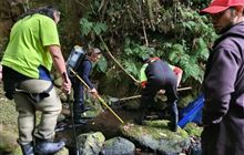
Modifying a ford to enable fish to pass
A ford on the lower section of river was preventing most native fish from moving upstream into the higher parts of the catchment. At this point the river is large and subject to flooding, but the ford provides access for local people and logging trucks.
Fixing the ford is a significant project because many different fish species need access up and downstream during times of low flow as well as during floods.
Monitoring fish communities above and below the ford began in 2016. This work led to fish ramps being installed at both sides of the ford in June 2017. Two more ramps were installed in Sept 2019. In February 2020, boulders in the stream were moved to make the ramps easier for fish to use.
Further monitoring on both sides of the ford has shown that not all fish species are able to pass. The ford’s upstream edge is currently acting as a weir. It also stops the riverbed’s natural movement during floods. Modifications to this edge are planned, and work on a permanent solution to provide fish passage is continuing.
Headwater farmland
Several large streams and wetlands are present in three separate farmed areas at the top of the catchment. The freshwater values in this area were first assessed in 2017.
The assessment provided background for discussions with the farm owners and Northland Regional Council about installing fencing and native planting beside the waterways. The work is intended to prevent nutrients, sediment and faecal contaminants entering the Waipoua River.
In 2019 we worked with one farmer and Northland Regional Council to fence off the most upstream section of the main Waipoua River and some adjoining wetlands.
In 2019–2020 we worked with the second farmer to fence the headwater streams and wetlands. Work with the third farmer to fence the final section of river was in progress in 2023. Planting will be completed with Northland Regional Council in subsequent years.
Fish surveys, monitoring and research
We began studying the river’s fish populations with Te Roroa in 2016.
These studies were followed up with night-time spotlighting surveys at representative sites in 2019 and are scheduled for completion in 2023. The surveys have revealed previously unknown populations of threatened shortjaw kōkopu in the upper part of the river.
Finding shortjaw kōkopu in good numbers has enabled us to start more intensive surveys to find out where they live and where they spawn.
We are using environmental DNA sampling to identify tributaries to study further.
Catchment monitoring
DOC and Te Roroa are working together to design and implement a catchment-scale monitoring programme to assess the river’s ecological integrity.
Ecological integrity measures the health of an ecosystem by considering how native, pristine, diverse and resilient it is. This project is training and working alongside local people to carry out the monitoring work.
Water quality monitoring
DOC and Te Roroa are working with Northland Regional Council to provide better real-time monitoring of the quality and quantity of river water. The council is also part of a technical group supporting the restoration work.
Erosion studies
Although it is a natural process, bank erosion contributes to a build-up of sediment in the river. A survey of the river downstream of the state highway bridge will identify and characterise where erosion of the banks is occurring.
Several of the sites will be surveyed in detail to enable changes to be tracked. Depending on the survey results, restoration work at one demonstration site will be trialled.
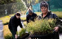
Replanting with native plants including kauri
Previous replanting in the catchment has been successful in converting farmland to kauri forest. We support the Native Forest Restoration Trust, which is restoring former pasture and pine forest land around the southern streams in the catchment.
The Waipoua nursery in the lower catchment is growing locally sourced natives for replanting in riparian areas.
Wetland mapping
Many of the wetlands in the Waipoua River catchment are not mapped. We are working with a contractor to assess the wetland area by desktop, then using ground methods to check the extent and type of wetland has been correctly assigned.
Once correctly mapped, the wetlands can be fenced and restored as fully functioning parts of the river system.
Feral pig disturbance
The effects of pigs on land around the river’s tributaries were analysed by a data ecologist in 2022. The analysis confirmed anecdotal evidence that pigs tend to disturb ground near waterways, which can increase the amount of sediment entering the river.
Ground disturbance monitoring has been in place since 2016 when feral pig control in the area began.
Weed management
Large areas of the lower catchment are covered in weeds including wilding pines, tobacco weed, ginger, pampas, montbretia and gorse.
Long term control and replanting with natives is being carried out in some areas – different approaches are being trialled find the most cost-effective method. DOC undertook extensive weed control work on the riverbanks from the ford to the headwaters from 2001–2010.
Waipoua catchment restoration work
Te Roroa iwi initiated a project called Te Toa Whenua to restore land returned to Te Roroa as part of the iwi settlement. Te Toa Whenua received support from the DOC Community Fund in 2016/17 and in 2019/20. Te Toa Whenua has also been supported by other organisations including Reconnecting Northland, Northland Regional Council and the Tindall Foundation.
Te Roroa received funding from the Ministry of Environment's Freshwater Improvement Fund in 2017. The project sought to address the major pressures on the river and fence headwater tributaries and wetlands to exclude stock, identify and protect eroded areas to reduce sediment run-off and provide instream habitat for native fish species.
Te Roroa have retired more than 600 hectares of plantation forest to create a continuous corridor of native revegetation along the lower margins of the river.
Kauri dieback is present in Waipoua Forest and its management is a priority for Te Roroa and DOC. To minimise the spread of the disease, walking tracks and predator trap lines have been closed or re-routed to avoid high-risk areas. Reducing pig numbers to low levels is likely to reduce the risk of infected soil being spread around the forest. This also reduces sediment entering the river via tributaries in the upper catchment. Biosecurity New Zealand and Northland Regional Council have used Lidar (a precise mapping technology) to support this work.
The Waipoua Forest Trust has a number of projects in the area, including replanting, pest trapping and dotterel monitoring at the coast, including near the Waipoua River mouth.
The Native Forest Restoration Trust owns several blocks of regenerating forest in the Waipoua catchment and continues to seek funding to secure other land in the catchment.
Native species present
A range of taonga and threatened species are present in the catchment:
- fish: shortjaw kokopu, longfin eel/tuna, lamprey/pihoro/kanakana, koaro and torrentfish
- plants: kauri forest, a Nationally Critical fungus (undescribed genus—Trichocomaceae), a moss (Fissidens integerrimus), native oxtongue, king fern and Bartlett’s koromiko
- birds: Australasian bittern/matuku-hūrepo (Nationally endangered), North Island brown kiwi North Island kaka, kōkako, brown kiwi and fernbird/matātā
- other species: land and kauri snails, forest ringlet butterfly, Otekauri (ground weta) and Waipoua beetle
LEARNZ field trip resources
In 2022, LEARNZ took a field trip to the Waipoua River and spoke to some of the people involved in the restoration work.
Contact
If you have any questions or want to get involved, email us.
Email: info@doc.govt.nz
![]()
About Ngā Awa river restoration
Ngā Awa is a programme working collaboratively in priority catchments to restore freshwater biodiversity.