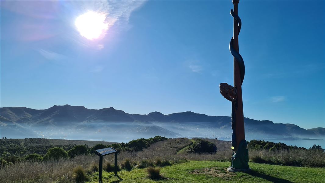
Pou whenua (land post)
At the highest point on Ōtamahua is a pou whenua, installed and blessed by the local hapū o Ngāti Wheke in May 2019.
Pou whenua are used by Māori to mark territorial boundaries and areas of significance. With funding assistance from the Ngāi Tahu Fund, Ngāti Wheke commissioned Whakaraupō Carving Centre to create the impressive pou. Carved from one giant log over 3 months, it is nearly 9 m tall and weighs 650 kg.
The pou is called ‘Te Hamo o Tū Te Rakiwhānoa’. A hamo is a multi-purpose tool used to clear debris and dig holes to plant vegetables. Tū Te Rakiwhānoa is one of the tūpuna (ancestors) of Ngāti Wheke.
The story goes that Tū Te Rakiwhānoa was on a quest to restore the waka Aoraki, and he used his hamo to clear the debris away from the waka. A taniwha (monster) named Koiro Nui Te Whenua was causing havoc in the area. Tū Te Rakiwhānoa – with the help of his cousins, Kahukura and Marukura – used the debris cleared from their waka to bury the taniwha.
On the side of the pou you’ll see a piece jutting out, called the teka. The ancestors would put their foot on this as they held the kō (digging stick) to dig holes and plant kūmara. The teka itself is different on each side; it represents the two whānau who helped Tū Te Rakiwhānoa keep the taniwha in its hole underneath the island.
Interpretive displays can be found in the historic Barracks building at Whakamaru beach, illustrating the cultual and natual history of the island. There are also interpretation panels along the Ōtamahua/Quail Island Loop Track
Early history
Ōtamahua means the place where children collect seabird eggs, it was also once known as "Te Kawakawa" likely referring to the kawakawa (pepper tree) of the same name.
The island appears to have been uninhabited, but was visited often to collect shellfish, flax, bird’s eggs and other foods. Fine stone from nearby Aua/King Billy Island was used to work greenstone/pounamu.
Captain Mein Smith named the island ‘Quail’ after seeing native quail/koreke here in 1842; they were extinct by 1875.
Agriculture and quarantine station
The island's history of agriculture began in 1851 with the Ward brothers. After two of the brothers drowned in the harbour, the island passed through several hands until it was established as a Quarantine Station in 1875 for new immigrants. Later the island was used as an important animal quarantine facility.
Emigrating to New Zealand in the 1800s was no easy feat. Long sea voyages in cramped, dirty conditions meant passengers were at risk of getting sick. To keep disease from spreading across the country, single men with signs of illness were quarantined on the island until they were declared healthy.
The quarantine station played an important role in managing outbreaks of disease - including a diphtheria outbreak at the Lyttelton Orphanage and two devastating waves of the 1918 Spanish influenza epidemic.
In 1907 the only leprosy colony in New Zealand was established on the island, and this housed several patients until 1925, when the remaining lepers were sent to a colony in Fiji.
After the turn of the century, when Antarctic exploration was at its peak, the island was used to quarantine and train dogs and ponies for Scott and Shackleton’s expeditions.
There are replica dog kennels and a replica leprosy patient’s hut built on the island by students of Cathedral College. The quarantine barracks have been restored and moved down to the beach front. These historic sites offer glimpses into the island's rich history.
Recreation reserve
The island was declared a recreation reserve in 1975 and has since been enjoyed by locals and visitors for its sheltered beaches, walking tracks, historical sites and ecological restoration programme.