- Fitness required: Low to moderate
- Gradient: Predominantly flat or gentle gradient, with a few short climbing sections
Image gallery
Video
From the Taylors Mistake car park, turn right and make your way behind the beach to the start of the Pilgrims Way Coastal Track. Climbing above the sea, the track offers views of places where old cave dwellings were built into the hillside. There are also views down to the rocks and sea below.
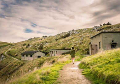
The engine room and battery plotting room
Image: Shelley Evans | Creative Commons
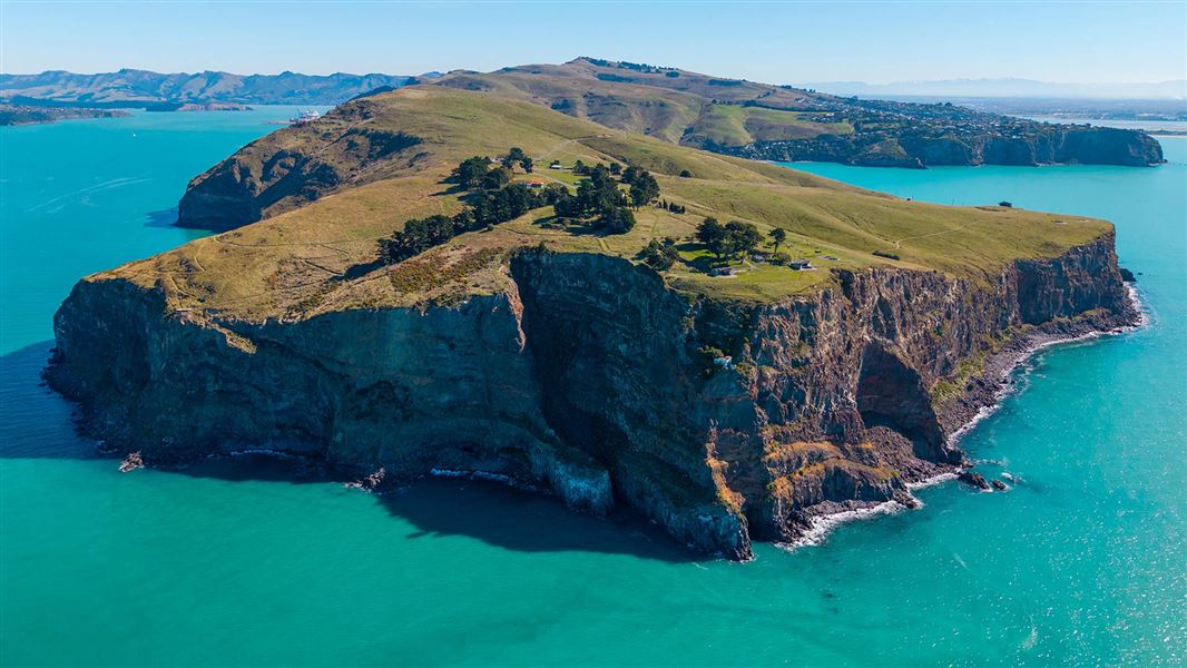
Passing Boulder Bay and the access to the two first gun platforms, the track climbs up to the headland and the historic Godley Head coastal defence battery.
From the battery there are dramatic views of:
- Christchurch
- the coastline heading north to the distant Kaikoura ranges
- the south east towards the headlands of numerous Banks Peninsula bays.
The gun emplacements have interpretative graffiti which celebrates the role of the Women's Auxiliary Army Corp in running the place during World War II. It also has a lighted underground magazine to explore. Interpretation panels tell the history of the site.
The Godley Head Gun Emplacements Track carries on around the nose of the headland, past the historic military buildings. This area includes the battery observation posts located at the entrance to Lyttelton Harbour. It ends at the public car park at Godley Head.
From the car park, the track climbs high above Breeze Bay where there are views of Lyttelton Harbour and Banks Peninsula. The track then drops back down to Breeze Col.
From Breeze Col follow the Black Rock track down for 20 minutes to the Pilgrims Way Coastal Track. Turn left there to walk back to Taylors Mistake Beach and the car park.
Accommodation
There are two places you can stay overnight:
Detour to Scott's Cabin
Easily accessed from the historic military compound on Godley Head, you can take the short easy walk to visit the historic Scott's Cabin.
Mountain biking
Mountain biing is not allowed on the Godley Head Loop Track but there are several other tracks in the area which do allow mountain biking.
The Christchurch City Council website has more information:
From the centre of Christchurch, it's a 30 minute drive to the coastal suburb of Sumner. From Sumner, it's another 10 minute drive over the hill to Taylors Mistake where there is ample parking at the track start.
You can also start the track from the car park at the Godley Head end of the Summit Road (50 minutes from Christchurch CBD). The Summit Road to Godley Head is sealed but narrow, with sharp corners and steep drops. The road is also popular with cyclists so take care.
- There are steep, unfenced cliffs – stay on the formed track and keep children under close supervision at all times.
- Toilets are available at Godley Head car park and at Taylors Mistake.
- Livestock graze in this area. Give livestock space and shut gates behind you. Keep dogs on leads.
- The sealed road to this track is narrow, has sharp corners and steep drops off the sides. Drive with care.
- The Summit Road to Godley Head is popular with cyclists. Keep left, reduce speed and keep a lookout for oncoming cyclists.
You must have a permit to fly a drone on public conservation land.
The track has provided access to Godley Head and the military installations and remnants since first constructed before World War II. It follows what was known as “Pilgrims Way”, an historic access track that also provides access to fishing locations and a number of baches at Boulder Bay.
Arthur's Pass National Park Visitor Centre
| Phone: | +64 3 318 9211 |
| Email: | arthurspassvc@doc.govt.nz |
| Address: | 104 West Coast Road Arthur's Pass 7654 |
| Hours: | Visitor centre hours and services |