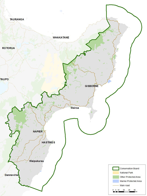
East Coast Hawke's Bay Conservation Board district
Introduction
Each Conservation Board operates in a geographical jurisdiction determined by the Minister of Conservation. Find out about the East Coast Hawke’s Bay Conservation Board district.The boards’ area of jurisdiction extends from Te Araroa, north of Gisborne, to Mangaorapa in Central Hawke's Bay on the East Coast of the North Island.
Significant areas
Boundary Stream Mainland Island is home to a number of threatened species including North Island brown kiwi, kākā and kōkako, New Zealand falcon (karearea) and kererū.
Cape Kidnappers/Te Kauwae-a-Māui Gannet Reserve is managed by DOC to protect gannet nesting sites. The 13 ha reserve includes the Saddle and Black Reef gannet colonies.
Kaweka Forest Park is characterised by alpine shrublands, tussock valleys and beech forests with pockets of podocarp. Many native birds can be found in the area including the North Island brown kiwi, karearea, North Island kaka, and the blue duck. Ten native freshwater fish species has been recorded in the Mohaka River.
Otatara Pa Historic Reserve is one of the largest and most ancient Maori pa sites in the Hawke's Bay. It is significant for its immense size and for the large number of terraced dwelling sites and food pits. Remnant earthworks of many of these are still evident today.
Te Angiangi Marine Reserve is on the central Hawke's Bay coast approximately 30 km east of Waipukurau and Waipawa, and the reserve protects 446 ha of coastline. The reserve is special in that it contains several marine habitat types, including boulder bank area, rocky intertidal platforms and a sheltered bay that is perfect for snorkelling.
Te Tapuwae o Rongokako Marine Reserve protects approximately 2,450 ha of coastline and contains eight marine habitat types that are representative of the area, including inshore reef, rocky intertidal platforms and sediment flats. Kelp forests, marine snails, kina, sponges, seaweed and a diverse range of fish can be found in the reserve.
Raukumara Forest Park is on the East Coast is one of the least developed or visited tracts of bush in the North Island. Recreation opportunities include climbing Mount Hikurangi, rafting the Motu River and mountain biking Otipi Road.
Cooks Cove Walkway was named after the Cove and the English sailor and explorer, Captain James Cook. He visited the area in 1769 as part of his circumnavigation of New Zealand. The walkway is situated at the southern end of Tolaga Bay, 52 km north of Gisborne.
Cook Landing Site National Historic Reserve in Gisborne commemorates the first landing place of James Cook in New Zealand in 1769. The site is believed to be within a short distance of the actual landing site, and not far from Te Toka a Taiau where the first significant meeting between Maori and European took place.
Gray's Bush Scenic Reserve is a small but highly signficant remnant of the tall, kahikatea (podocarp) forest which once covered much of the Gisborne Plains. Forested areas are rare on the plains which have been extensively cleared and drained for pastoral farming and agriculture. It is semi-coastal in character and has a dominant canopy of kahikatea, with significant presence of puriri. It also provides a nesting and feeding habitat for a number of different bird species both native and introduced.

