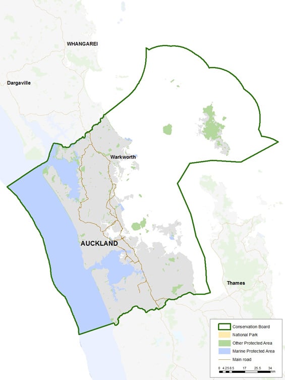
Auckland Conservation Board district
Introduction
Find out about the area the Auckland Conservation Board covers and the threatened species present.Area covered by the conservation board
The board's area of jurisdiction extends from the west coast to the east coast in the narrowist part of New Zealand. The entrance to the Kaipara Harbour marks the north western corner of the region and Mangawhai Heads, the north eastern point. In the southwest the boundary follows the north bank of the Waikato River and the south eastern boundary is on the Firth of Thames at Miranda.
The area also extends out to the 12 nautical mile limit with respect to coastal and marine issues, and out to the 200-nautical mile limit with respect to protected species.
Significant sites
Auckland City is home to one third of New Zealands population and sees 5 million domestic and international visitors each year; the boards district is unique in that it comprises this highly urbanised environment of the Auckland Metropolitan area.
The Firth of Thames, a wetland of international significance. The site includes shallow estuarine water and mudflats, shell banks, grass flats, mangrove forest, saltmarsh and limited freshwater swamp margins, supporting a wide array of bird life.
Te Hauturu-o-Toi / Little Barrier Island is New Zealand's first nature reserve, established in 1896. Te Hauturu o Toi – the resting place of the wind – is the gold standard for predator free New Zealand and often described as DOCs most intact ecosystem, it is without doubt one of the most important reserves of its kind in the world.
Great Barrier Island/Aotea Conservation Park spreads over more than 12,000 hectares and has the only multi-day wilderness walk in the Auckland region.
Tiritiri Matangi Island is rich in Māori and European history with one of the most successful community-lead conservation projects in the world. Rare native birds, such as the kōkako and the takahē (once thought to be extinct), survive and thrive in restored and regenerating native forest.
Map

Threatened species
The Auckland Conservation Board has a responsibility to monitor and advise on the implementation of the Auckland Conservation Management Strategy 2014 – 2024. Protecting and restoring populations of threatened species is a key objective in the strategy.
The conservation status of native species within the Auckland Region may be inconsistent with their national status. An example of this is the spotted shag, which at a national level is listed as ‘Threatened, nationally vulnerable’ but at a regional level is locally extinct in parts of the Hauraki Gulf.
DOC provided the Conservation Board with updated lists of threatened species in the Auckland region in September 2022, which the Board is using to track progress.
Fauna
The threatened fauna (vertebrates) list is based on the list of ‘Threatened’ or ‘At Risk’ vertebrate fauna in Appendix 6 of the Conservation Management Strategy. It has been updated to reflect changes in taxonomy and threat status, however the list may not capture changes in species distribution or newly described species.
Auckland threatened fauna report (PDF, 234K)
Flora
The threatened flora list is a comprehensive list of all threatened plants in the Auckland Region, including those listed in Appendix 6 of the Conservation Management Strategy. It also includes species that have been identified as being threatened in the region in the period since the Conservation Management Strategy was published in 2014.
Auckland threatened flora report (PDF, 391K)
Auckland council assessment
In December 2022, Auckland Council published an assessment of the regional conservation status of native vascular plant species found within the Auckland region. This assessment was produced by local botanical authorities and should be consulted in respect of threatened and at risk plants within the Auckland region.
Conservation status of vascular plant species in Tāmaki Makaurau / Auckland (PDF, 2,936K)
