33 km one way
In the Great Walks season (1 November 2025 – 30 April 2026)
Best time to walk the track - there are more facilities and fewer hazards. Bookings are required for huts and campsites. Intermediate track category.
Outside the Great Walks season (1 May 2025 – 31 October 2025)
It can be cold and wet, with ice, snow and short daylight hours. Walking the track should only be attempted by fit, experienced and well-equipped people with alpine, river crossing and navigation skills. Facilities are greatly reduced and there are additional hazards. Advanced and expert track categories.
Video
May to late October (winter season): Walking the track outside the Great Walks season should only be attempted if you have alpine skills, equipment and experience.
Walking options
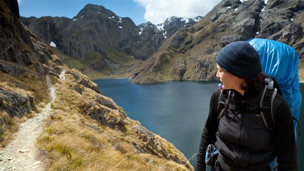
The Routeburn Track can be walked in either direction.
Most walkers take 3 days/2 nights usually staying at Routeburn Falls and Lake Mackenzie Huts.
The trip can be extended by also staying at other huts, or made into a circuit by linking with the Greenstone and Caples Tracks, which starts and finishes near the Routeburn Shelter.
Enjoy a day walk: Earland Falls Track | Key Summit Track | Lake Howden Track | Routeburn Nature Walk
Explore on Google Street View | Watch videos
Places to stay
There are three huts and two campsites, which must be booked well in advance during the Great Walks season.
Huts have bunks, mattresses, heating, toilets, basic cooking facilities, solar-powered lighting and cold running water. A DOC ranger is in residence. Huts do not have food, cooking utensils, showers or bedding.
Campsites have basic facilities including toilets, sinks and a water supply. Routeburn campsites have picnic tables and cooking shelters. Campers can't use hut facilities.
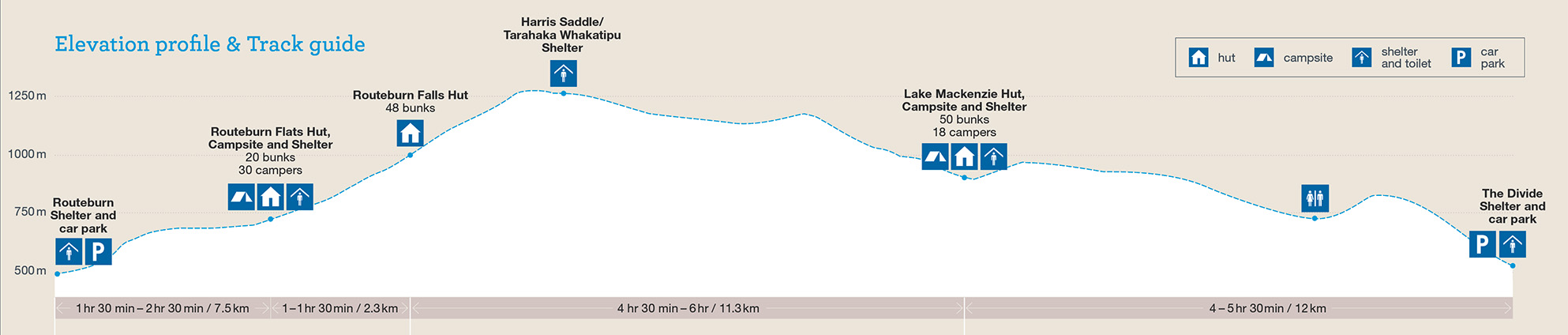
Routeburn Shelter to Routeburn Flats Hut
Time: 1 hr 30 min – 2 hr 30 min
Distance: 7.5 km
The track begins at Routeburn Shelter, gently winding alongside the crystal-clear Route Burn (river). After passing Sugarloaf Stream, you’ll climb to Bridal Veil Waterfall and continue above the gorge. A swing bridge leads to open grassed flats, and the Routeburn Flats Hut and Campsite.
Routeburn Flats Hut to Routeburn Falls Hut
Time: 1 – 1 hr 30 min
Distance: 2.3 km
The track climbs steadily through stunning beech forest, providing views of the Humboldt Mountains. End the day at Routeburn Falls Hut, on the edge of the bushline and close to the impressive Routeburn Falls cascade.
Routeburn Falls Hut to Lake Mackenzie Hut
Time: 4 hr 30 min – 6 hr
Distance: 11.3 km
Climb steadily up the valley, through wetlands and tussock-covered flats, before sidling along the bluffs above Lake Harris to reach the highest point on the track at Harris Saddle/Tarahaka Whakatipu (1,255 m).
Shortly after the Harris Saddle, the track brings you to Harris Saddle Shelter (day use only). Here you can take a break from the elements and use the toilet facilities provided.
The track then descends and traverses along the exposed Hollyford Face, with expansive views over the Darran Mountains. This section of the track is well-known for its impressive array of alpine plants. A steady descent leads to Lake Mackenzie Hut, set beside the enchanting Lake Mackenzie.
Side trip: Conical Hill
Time: 1 hr 30 min – 2 hr return
A short, steep climb from the Harris Saddle up Conical Hill gives superb views of the Hollyford Valley through to Lake McKerrow and beyond to Martins Bay and the Tasman Sea.
Be aware:
- Snow and ice can sometimes make this trip hazardous early and late into the Great Walks season.
- Due to rock fall danger, observe the no stopping zones along this track.
Mackenzie Hut to The Divide
Time: 4 – 5 hr 30 min
Distance: 12 km
Leaving Lake Mackenzie Hut the track crosses a small flat before climbing to the bush line. A gradual descent then leads past the ‘Orchard’, an open grassy area dotted with ribbonwood trees, to the impressive Earland Falls (174 m). The track continues its descent through beech forest to Lake Howden (Lake Howden Hut was destroyed by storm damage in February 2020).
From Lake Howden, the well graded track climbs steadily for about 15 minutes to the Key Summit Track turn-off. From the Key Summit turn-off, the gradual downhill walk is through silver beech forest to The Divide on the Milford Highway. At 532 m, The Divide is the lowest crossing of the Southern Alps in New Zealand.
Side trip: Key Summit
Time: 1 – 1 hr 30 min return
This popular walk climbs above the bushline to an alpine wetland and, in good weather, offers magnificent views of the Darran Mountains and the Hollyford valley. A self-guided alpine nature walk passes a range of native vegetation: beech forest, subalpine shrublands and alpine tarns and bogs. Birdlife is prolific and tomtits, robins, New Zealand pigeons/kererū and bellbirds/korimako are commonly seen.
Understand if you are ready for the Routeburn Track
Watch the NZ Mountain Safety Council’s walk-through video which takes you through how to prepare for this track. Including facilities, key decision points, hazards and typical conditions for the area.
View more images of this track
You need to pay fees to stay at the huts and campsites on this track. Fees vary depending on when you go.
Prices are per person, per night. NZ rates are for New Zealand visitors and INT rates are for international visitors.
Huts
|
Date range |
Adult NZ |
Adult INT |
Child NZ |
Child INT |
Infant NZ |
|---|---|---|---|---|---|
|
1 November 2025 – 30 April 2026 |
$88 |
$132 |
$44 |
$66 |
Free |
|
1 May – 30 June 2026 |
$35 |
$35 |
$17.50 |
$17.50 |
Free |
|
1 July – 31 October 2025 |
$30 |
$30 |
$15 |
$15 |
Free |
Proof of eligibility is required for the New Zealand rate.
Campsites
Prices are per person, per night. NZ rates are for New Zealand visitors and INT rates are for international visitors.
|
Date range |
Adult NZ |
Adult INT |
Child NZ |
Child INT |
Infant NZ |
|---|---|---|---|---|---|
|
1 November 2025 – 30 April 2026 |
$28 |
$42 |
$14 |
$21 |
Free |
|
1 May – 30 June 2026 |
$10 |
$10 |
$5 |
$5 |
Free |
|
1 July – 31 October 2025 |
$10 |
$10 |
$5 |
$5 |
Free |
Proof of eligibility is required for the New Zealand rate.
Bookings
In the Great Walks season (1 November 2025 – 30 April 2026)
Bookings are required for huts and campsites.
Book Routeburn Track huts online.
If you don’t have a valid booking for your stay, you may be charged a penalty, or turned away if the hut/campsite is full.
Outside the Great Walks season (1 May 2025 – 31 October 2025)
Bookings are not required.
Bunks in huts are first come, first served.
Payment is with Backcountry Hut Tickets or a Backcountry Hut Pass – buy these from a DOC visitor centre before you go or buy a Pass online.
Routeburn Track can be accessed from both ends: Routeburn Shelter, 25 km from Glenorchy along a partially unsealed road, and The Divide Shelter, 85 km from Te Anau.
The road distance between each end of the track is 325 km – transport is needed at each end.
Southland NZ and Destination Queenstown have information about transport operators.
When booking transport, avoid a pick up time that requires leaving the hut or campsite before it is light enough to walk safely. Walking in the dark is unsafe. Check the daylight hours on the NIWA weather web page.
May to late October – winter season
Special skills and preparation are required to complete the Routeburn Track in winter. Facilities are greatly reduced. There is increased risk from snow, ice, avalanche terrain and sub-zero temperatures.
There is no cellphone coverage.
Track not recommended for young children
Track is not recommended for children under the age of 10, due to the exposed mountainous environment and often adverse weather conditions.
There are steep drop-offs
There are steep drop-offs along sections of the whole track. The track is well marked and signposted, but some sections are steep and rough.
Weather conditions
Weather conditions can change quickly in any season. Fiordland National Park experiences very high rainfall (up to 9000 mm per year) and weather conditions can change quickly in any season. Cold temperatures, snow, strong winds and heavy rain can occur at any time of the year. Be prepared for all conditions. Check the Routeburn Track weather forecast – NIWA website.
Track flooding
After heavy rain, flooding is common on sections of the track. However, stream and river levels will drop quickly once the rain stops. If caught between streams in flood, do not attempt to cross. Turn back or wait for water levels to drop.
Avalanche risk
The risk of avalanche can extend into December. During the Great Walk season, DOC manages avalanche risk and sections of the track maybe closed if there is avalanche hazard.
Take precautions not to spread didymo
Didymo has been found at locations along the Routeburn Track, including at Potters Creek, Deadman’s Creek, and No Name Creek. These creeks are between Harris Saddle and Lake Mackenzie.
All visitors should take precautions when crossing streams to avoid transporting didymo to other areas along the Routeburn Track.
Use the Check, Clean Dry guidelines to ensure didymo is not spread to further pristine creeks. Do not take water from these areas and avoid filling water bottles here.
More information about preventing the spread of freshwater pests in Fiordland National Park.
Wasps and sandflies
There are wasps and sandflies. We recommend carrying insect repellent for sandflies and your medication if you are allergic to wasp stings (such as antihistamines).
Personal equipment
- Backpack – 40–60 litre size for multi-day hiking
- Waterproof/plastic pack liner
- Sleeping bag – 3–4 season
- First aid kit including blister treatment materials - see Mountain Safety Council first aid advice
- Survival kit including survival blanket, whistle, paper, pencil, high energy snack food
- Safety equipment relevant to the track and time of year, for example, map, compass
- Torch/flashlight and spare batteries
- Rubbish bag
- Booking confirmation and ID
- Earplugs for communal bunkrooms
- An emergency shelter, for if you are trapped by flooded rivers or bad weather
- A distress beacon
Cooking and food equipment
- Drink bottle – 1–2 litre capacity
- Eating and cooking utensils – knife, fork, spoon, plate, cup, pot/pan/billy, cleaning kit, tea towel. Check individual huts for what cooking facilities and lighting are provided.
- Matches or lighter in waterproof container
Toiletries
- Toiletries, including insect repellent, sunscreen, and personal medication, for example, antihistamine for allergy to wasp stings
- Use a toilet when you see one and be prepared with a backup toilet option
- Some of our Great Walk huts have sanitary bins but do come prepared if there isn't one. Find out more about Menstruation in the backcountry.
If camping
- Tent
- Sleeping mat
- Ground sheet
- Gas cooker
Clothing
- For multi-day walking you'll need at least one set of clothes to walk in and another dry set to change into at night.
- Tramping/hiking boots or firm footwear – should be comfortable and well broken in
- Socks – wool or polypropylene
- Shorts – quick dry material
- Shirt – wool or polypropylene
- Under layers, top and bottom – wool or polypropylene
- Mid-layers – wool or polar fleece
- Raincoat – waterproof, windproof with hood
- Overtrousers – wind and waterproof
- Warm hat and gloves
- Sunhat and sunglasses
- Extra socks, underwear, shirt/lightweight jersey
Optional
- Gaiters
- Lightweight shoes for inside the huts
- Fire starters
Food
You cannot buy food on the track. Carry all the meals and snacks you will need, plus some spare, and a water bottle. We recommend food that is lightweight, fast cooking and high in energy value.
We do not provide emergency food in huts. You will need to carry emergency food supplies in case you are delayed by weather.
Store your food in a rodent-proof container or bag. This is especially important if you are camping
May to early November
For safety reasons the Routeburn Track doesn't operate as a Great Walk/Easier tramping track during May to early November. If attempting the Routeburn Track at that time, you'll need additional equipment:
- food for at least two extra days
- stove and gas for cooking
- lighter or matches
- alpine equipment: ice axe and crampons
- avalanche equipment: beacon, snow shovel, avalanche probe
- personal locator beacon
- satellite messenger (optional).
Outside the Great Walks season (1 May 2025 – 31 October 2025)
- It can be cold and wet, with ice, snow and short daylight hours.
- Avalanche-prone bridges across some major watercourses are removed.
- DOC does not manage hazards such as flooding and avalanches.
- Facilities are greatly reduced.
Walking the track at this time should only be attempted if you are fit, experienced and well equipped.
Routeburn Track winter tramping safety information (PDF, 673K)
Fees and bookings
Outside of the Great Walks season, hut fees are reduced and bookings are not required. Full information can be found in the fees and booking section for this track.
Expect challenging conditions
Bridges between Lake Mackenzie and Harris Saddle may be removed over winter to avoid damage from avalanches, so you must be competent at crossing swift, icy side streams.
Snow and ice conditions on the Hollyford face and at the Harris Saddle can be extremely dangerous. View current conditions on the Harris Saddle webcam.
Lake Mackenzie is not safe to walk on when frozen.
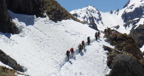
Climbing up to Harris Saddle in spring
Image: DOC
Conditions will be wet and cold with snow
During the winter months Fiordland can be very wet and cold. Daylight is limited and the high mountains let little sunlight into the valleys. Alpine areas are usually covered in snow. Dress for these conditions.
Avalanches will be frequent
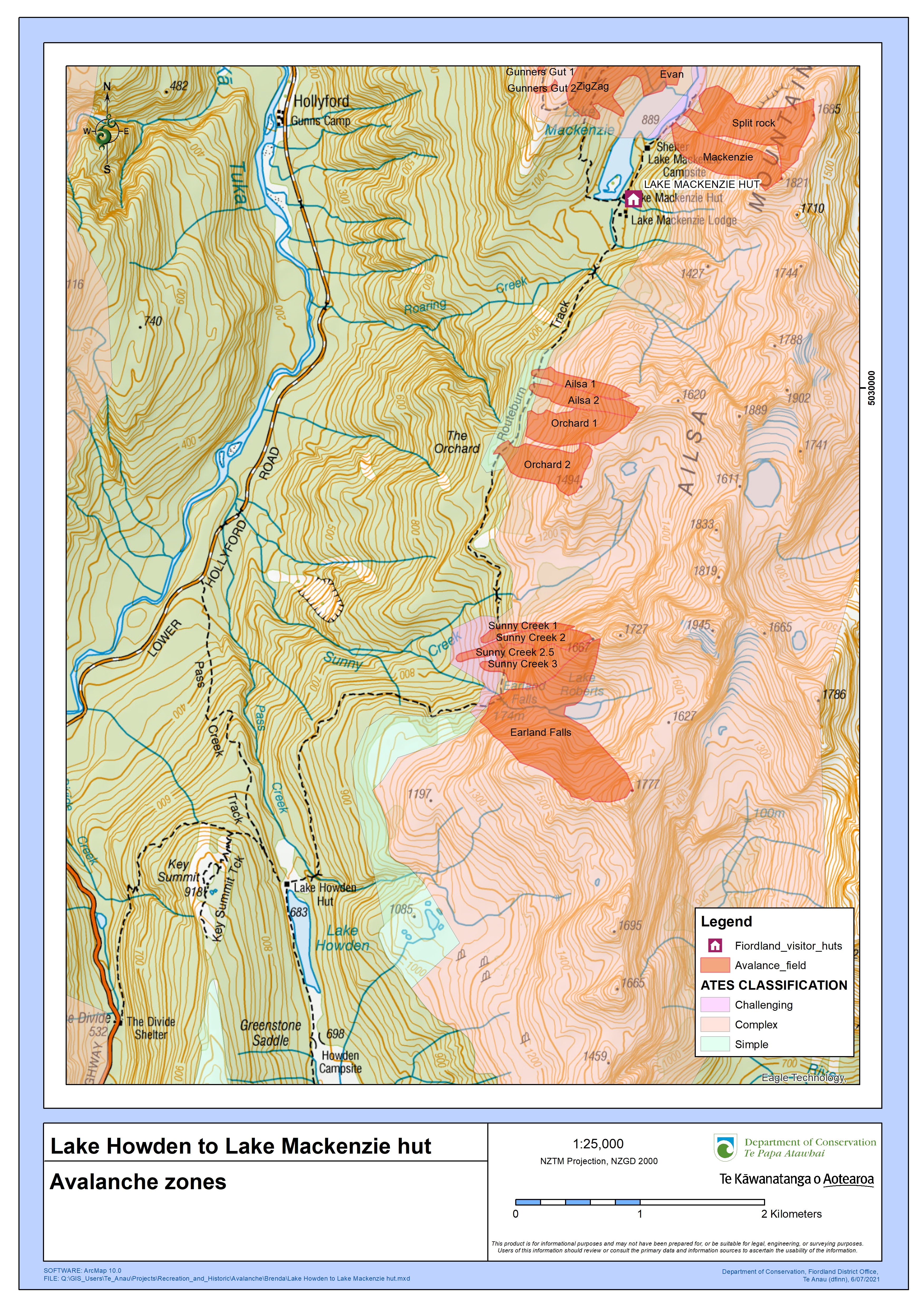
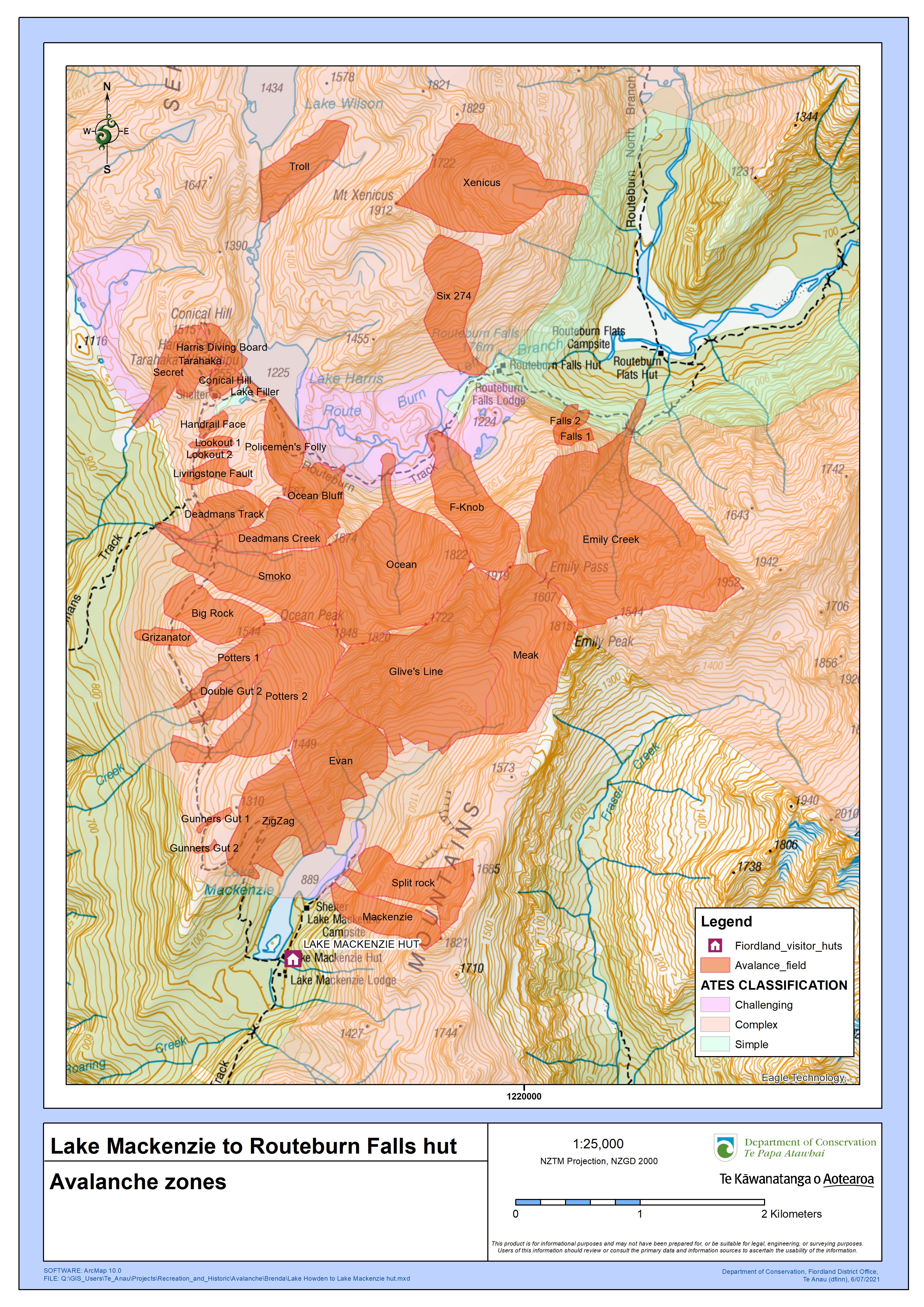
The Routeburn Track has a lot of challenging and complex avalanche terrain. Avalanches are frequent. There are over 32 avalanche paths, some of which may bring avalanche debris to the valley floor and have the potential to cross the Routeburn Track.
If you are going into places avalanches could occur, be sure you:
- have checked the New Zealand Avalanche Advisory for Fiordland, the Avalanche Terrain Exposure Scale (ATES) for Wakatipu, Wanaka and Central Otago and Avalanche Terrain Exposure Scale (ATES) for Fiordland National Park.
- have the skills for the ATES class you are going into
- have checked what avalanche advisory and alert information is available from the DOC visitor centre nearest the area where you want to go
- take an avalanche transceiver, avalanche probe and a snow shovel. Know how to use these tools.
Maps of avalanche paths: Lake Howden to Lake MacKenzie (JPG, 9,111K) | Lake MacKenzie to Falls Hut (JPG, 9,186K)
Expect reduced hut facilities
- Gas is not provided – you will need to bring your own cooking stove.
- Flush toilets are replaced with pit toilets.
- Running water is turned off inside the huts. Water can be obtained from the outside water tank; if this is frozen, then from the nearest water course or by melting snow.
- No rangers based at the huts.
Expect reduced transport services
All transport must be arranged before starting the track. During winter, transport operators require minimum numbers and do not always operate a daily service. Transport arrangements can be affected by bad weather. You must discuss an alternative option with transport operators before you begin your walk.
Be totally self-sufficient
You need to be totally self-sufficient. In addition to what to take in the Great Walks season, you also need:
- food for at least two extra days
- stove and gas for cooking
- lighter or matches
- alpine equipment: ice axe and crampons
- avalanche equipment: beacon, snow shovel, avalanche probe
- personal locator beacon
- satellite messenger (optional)
Read our Conservation Blog: Hiking the Routeburn Track outside the Great Walks season (May to October)
View more images of this track
Nature's in trouble
Thousands of New Zealand’s native species are heading towards extinction. Once they’re gone, they’re gone for good. Nature needs your help.
Stay safe in the outdoors
- Choose the right trip for you. Learn about the route and make sure you have the skills for it.
- Understand the weather. Check weather forecasts.
- Pack warm clothes and extra food. Check gear lists.
- Share your plans and take ways to get help. Leave your intentions with a trusted contact and take a distress beacon.
- Take care of yourself and each other.
Te Rua-o-te-moko/Fiordland National Park Visitor Centre
| Phone: | +64 3 249 7924 |
| Email: | fiordlandvc@doc.govt.nz |
| Address: | 1 Lakefront Drive Te Anau 9600 |
| Hours: | Visitor centre hours and services |
Whakatipu-wai-Māori/Queenstown Visitor Centre
| Phone: | +64 3 442 7935 |
| Email: | queenstownvc@doc.govt.nz |
| Address: |
50 Stanley Street |
| Hours: | Visitor centre hours and services |