53.5 km one way
In the Great Walks season (24 November 2025 – 30 April 2026 last departure 28 April 2026)
Best time to walk the track - there are more facilities and fewer hazards. Bookings are required for huts and transport. Intermediate track category.
Outside the Great Walks season (1 May 2025 – 23 November 2025)
It can be cold and wet, with ice, snow and short daylight hours. Walking the track should only be attempted by fit, experienced and well-equipped people with alpine, river crossing and navigation skills. Facilities are greatly reduced and there are additional hazards. Advanced and expert track categories.
Walking options
The Milford Track can only be walked in one direction over 3 nights and 4 days.
Guided options
Consider guided walks on the Milford Track (Visit Fiordland website)
Explore with Google Street View | Watch videos
Places to stay
There are three huts on the Milford Track, which must be booked well in advance during the Great Walks season. Camping is not permitted on the Milford Track.
Huts have bunks, mattresses, heating, toilets, basic cooking facilities, solar-powered lighting and cold running water. A DOC ranger is in residence. The huts do not provide cooking utensils or showers.
Day 1 – Glade Wharf to Clinton Hut
Time: 1–1 hr 30 min
Distance: 5 km
After a boat cruise from Te Anau Downs (1 hour 15 minutes), take a leisurely walk through beautiful beech forest along the banks of the Clinton River to Clinton Hut, where all walkers spend the first night. Once you arrive, take some time to checkout the great swimming holes near the hut, or take a short walk around the wetland boardwalk.
Side trip: Wetland Walkway
Time: 15 min return
A short side track is signposted 10 min before Clinton Hut. Guided walks with the DOC ranger maybe available during the late afternoon.
Day 2 – Clinton Hut to Mintaro Hut
Time: 6 hr
Distance: 17.5 km
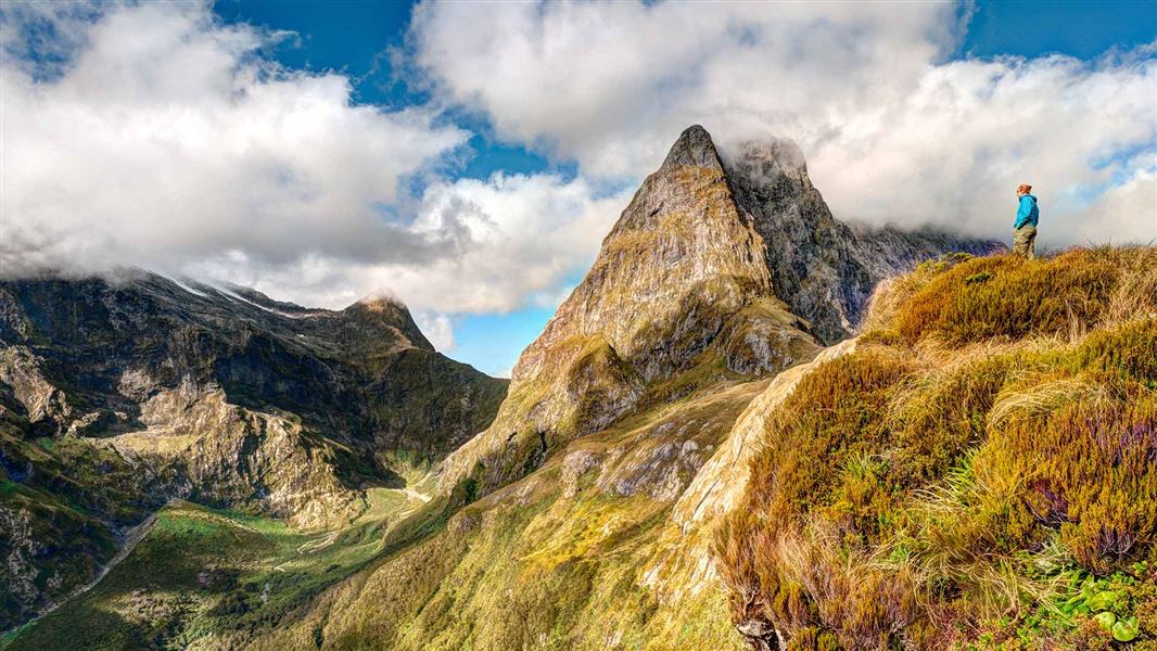
A gradual climb follows the Clinton River to its source, Lake Mintaro, at the base of the renowned Omanui/McKinnon Pass. Past Hirere Falls you will get your first view of Omanui/McKinnon Pass and the impressive Pompolona icefield. You’ll be dwarfed by the sheer scale of the rock walls towering above on either side as you walk up the Clinton Valley, and will pass through changing vegetation as you climb higher towards Mintaro Hut.
Day 3 – Mintaro Hut to Dumpling Hut
Time: 6–7 hr
Distance: 13 km
Climb to Omanui/McKinnon Pass and the memorial to explorer Quintin McKinnon, with exceptional views of Lake Mintaro and the Clinton Canyon along the way. The memorial is a great place to take in the awe-inspiring panoramas, before reaching the highest point of the track and Omanui/McKinnon Pass Shelter (1154 m).
From here, you’ll drop steadily through an attractive alpine garden to the valley floor, passing several waterfalls along the Roaring Burn River before arriving at Quintin Shelter. On the way to Dumpling Hut take a moment to admire Sutherland Falls in the distance.
Side trip – Sutherland Falls
Time: 1 hr 30 min return
The side trip to Sutherland Falls is a definite highlight that is highly recommended and well worth the effort. The impressive falls drop 580 m in 3 leaps from Lake Quill.
Sutherland Falls on Google Street View
Day 4 – Dumpling Hut to Sandfly Point
Time: 5 hr 30 min – 6 hr
Distance: 18 km
From Dumpling Hut, follow Arthur River to the historic Boatshed. Further along the track, you will reach the dramatic Mackay Falls and intriguing Bell Rock. Admire the man-made rock cuttings alongside the Arthur River and Lake Ada, before spending the last 3 km on a smooth, wide track constructed by a prison labour gang between 1890 and 1892.
A short boat ride from Sandfly Point will take you to your journey’s end, with world-famous views of Milford Sound/Piopiotahi along the way.
Understand if you are ready for the Milford Track
Watch the NZ Mountain Safety Council’s walk-through video which takes you through how to prepare for this track. Including facilities, key decision points, hazards and typical conditions for the area.
You need to pay fees to stay at the huts on this track. Fees vary depending on when you go.
Prices are per person, per night. NZ rates are for New Zealand visitors and INT rates are for international visitors.
Huts
|
Date range |
Adult NZ |
Adult INT |
Child NZ |
Child INT |
Infant NZ |
|---|---|---|---|---|---|
|
28 October 2025 – 30 April 2026 |
$106 |
$152 |
$53 |
$76 |
Free |
|
1 July– 27 October 2025 |
$30 |
$30 |
$15 |
$15 |
Free |
Proof of eligibility is required for the New Zealand rate.
Bookings
In the Great Walks season (24 November 2025 – 30 April 2026 last departure 28 April 2026)
Book Milford Track huts online.
If you don’t have a valid booking for your stay, you may be charged a penalty, or turned away if the hut is full.
Outside the Great Walks season (1 May 2025 – 23 November 2025)
Bookings are not required.
Bunks are first come, first served.
Payment is with Backcountry Hut Tickets or a Backcountry Hut Pass – buy these from a DOC visitor centre before you go or buy a Pass online.
The Milford Track starts on Lake Te Anau. From Te Anau, take a bus or private transport to Te Anau Downs (30 minutes), then a boat trip to Glade Wharf at the head of Lake Te Anau (1 hour 15 minutes).
The track finishes at Sandfly Point on Milford Sound. Take a boat trip (20 minutes) to Milford Sound/Piopiotahi, where there are bus services back to Te Anau and on to Queenstown.
Transport must be booked in advance. There is no vehicle or private access to the start/end of the track.
View map of transport to book (PDF, 1,339K)
Transport services in FiordlandDuring the Great Walks season, full and partial transport packages are available from one of these independent operators. Contact the operator for further information.
There is no cellphone coverage.
The track is not suitable for all walkers
It is not recommended for children under the age of 10, due to the exposed mountainous environment and often adverse weather conditions. Parts of the Milford Track are exposed, steep, slippery, rough and muddy. On the third day you will climb over 500 m to Omanui/McKinnon Pass and then descend 1000 m to Dumpling Hut. On the fourth day you must walk 18 km, reaching Sandfly Point in time to meet the early afternoon boat.
Weather conditions
Weather conditions can change quickly in any season. Fiordland National Park experiences very high rainfall (up to 9000 mm per year). Cold temperatures, snow, strong winds and heavy rain can occur at any time of the year. Be prepared for all conditions. Track closures are possible and may affect your travel itinerary. Travel insurance is recommended.
Avalanche risk
The risk of avalanche can extend into December. During the Great Walks season DOC manages this risk to a low level and walkers may be flown (at their cost) over dangerous sections.
Weather forecast
Milford Track weather forecast – NIWA website
View current conditions on the Omanui/McKinnon Pass webcam
Milford Track in November – cold temperatures, snow, strong winds and heavy rain can occur anytime.
Stay safe when crossing rivers
If you plan to cross unbridged rivers, know how to cross safely and be prepared for if you cannot cross.
Do not cross if the river is flooded, you cannot find safe entry and exit points or are unsure it’s safe. Turn back or wait for the river to drop. If in doubt, stay out.
NIWA river flow forecasts: View a video of national followed by regional river flows
Take precautions not to spread didymo
Didymo is present in Lake Te Anau and Milford Sound, but currently not in the pristine Clinton and Arthur rivers.
All visitors should take precautions to avoid spreading didymo. Be extra mindful when moving from the lake to the rivers along the Milford Track, and from the Fresh Water Basin in Milford Sound to the Arthur River.
Use the Check, Clean Dry guidelines to ensure didymo is not spread further. Do not take water from these areas, avoid filling water bottles and swimming here (in the rivers after swimming the lakes).
More information about preventing the spread of freshwater pests in Fiordland National Park.
Personal equipment
- Backpack – 40–60 litre size for multi-day hiking
- Waterproof/plastic pack liner
- Sleeping bag – 3–4 season
- First aid kit including blister treatment materials - see Mountain Safety Council first aid advice
- Survival kit including survival blanket, whistle, paper, pencil, high energy snack food
- Safety equipment relevant to the track and time of year, for example, map, compass
- Torch/flashlight and spare batteries
- Rubbish bag
- Booking confirmation and ID
- Earplugs for communal bunkrooms
Cooking and food equipment
- Drink bottle – 1–2 litre capacity
- Eating and cooking utensils – knife, fork, spoon, plate, cup, pot/pan/billy, cleaning kit, tea towel. Check individual huts for what cooking facilities and lighting are provided.
- Matches or lighter in waterproof container
Toiletries
- Toiletries, including insect repellent, sunscreen, and personal medication, for example, antihistamine for allergy to wasp stings
- Use a toilet when you see one and be prepared with a backup toilet option
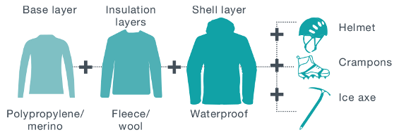
Clothing
- For multi-day walking you'll need at least one set of clothes to walk in and another dry set to change into at night.
- Tramping/hiking boots or firm footwear – should be comfortable and well broken in
- Socks – wool or polypropylene
- Shorts – quick dry material
- Shirt – wool or polypropylene
- Under layers, top and bottom – wool or polypropylene
- Mid-layers – wool or polar fleece
- Raincoat – waterproof, windproof with hood
- Overtrousers – wind and waterproof
- Warm hat and gloves
- Sunhat and sunglasses
- Extra socks, underwear, shirt/lightweight jersey
Optional
- Gaiters
- Lightweight shoes for inside the huts
Food
You cannot buy food on the track. Carry all the meals and snacks you will need, plus some spare, and a water bottle. We recommend food that is lightweight, fast cooking and high in energy value.
We do not provide emergency food in huts. You will need to carry emergency food supplies in case you are delayed by weather.
Store your food in a rodent-proof container or bag.
May to late October
For safety reasons the Milford Track doesn't operate as a Great Walk/Easier tramping track from May to late October. If attempting the Milford Track at that time, you'll need additional equipment:
- food for at least two extra days
- stove and gas for cooking
- lighter or matches
- alpine equipment: ice axe and crampons
- avalanche equipment: beacon, snow shovel, avalanche probe
- personal locator beacon
- satellite messenger (optional).
This is outside the Great Walks season.
- It can be cold and wet, with ice, snow and short daylight hours.
- DOC does not manage hazards such as flooding.
- Facilities are greatly reduced.
Walking the track at this time should only be attempted by fit, experienced and well equipped people.
May to early June (King’s Birthday weekend) is outside the Great Walks season. The track is unmanaged, more difficult, and there is higher risk from hazards like flooding.
Read the information below carefully and decide whether you want to walk the Milford Track outside the Great Walk season.
The track floods often and may be impassable
The Milford Track is not an all-weather track. Both the Clinton and Arthur Valleys become impassable during heavy rain, due to flooding. Heavy rain also increases the risk of landslides.
If you choose to walk the track outside the Great Walk season,– you need to understand the risks and have a plan for what to do if there is flooding.
There is no monitoring of weather forecasts and river levels outside of the Great Walk season. Trampers should monitor the severe weather on MetService for heavy rain in the Fiordland area.
If there is a heavy rain warning or a heavy rain watch for Fiordland during your scheduled tramp dates:
- for one day only – schedule an extra day / another night in a hut, so you are not walking on the track that day
- for more than one day – postpone your tramp until the weather improves.
There is no cell phone reception on the Milford Track. Carry a distress beacon and consider carrying an InReach, so you can communicate with your transport provider if you are delayed by weather.
Weather conditions
Fiordland National Park experiences very high rainfall (up to 9000 mm per year). Cold temperatures, snow, strong winds and heavy rain can occur at any time of the year – and will be more common in May and June than in the Great Walks season. Be prepared for all conditions.
The track is not suitable for all walkers
It is not recommended for children under the age of 10, due to the exposed mountainous environment and often adverse weather conditions. Parts of the Milford Track are exposed, steep, slippery, rough and muddy.
On the third day you will climb over 500 m to Omanui/McKinnon Pass and then descend 1000 m to Dumpling Hut. On the fourth day you must walk 18 km, reaching Sandfly Point in time to meet the early afternoon boat.
Weather forecast
This is outside the Great Walks season.
- It can be cold and wet, with ice, snow and short daylight hours.
- Avalanche-prone bridges across some major watercourses are removed.
- DOC does not manage hazards such as flooding and avalanches.
- Facilities are greatly reduced.
Walking the track at this time should only be attempted by fit, experienced and well equipped people
Milford Track winter tramping safety information (PDF, 1,183K)
Fees and bookings
Outside of the Great Walks season, hut fees are reduced and bookings are not required. Full information can be found in the fees and booking section for this track.
Expect challenging track conditions
Many of the bridges across side streams are removed over winter to avoid damage from avalanches. These side streams can rise very quickly, so you must be competent at crossing large, swift, icy rivers.
Weather forecast
Omanui/McKinnon Pass weather forecast – NIWA website
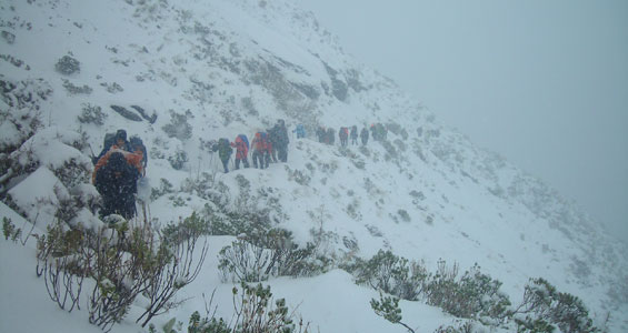
The track over Omanui/McKinnon Pass is not marked and is often covered in deep snow. You will need to have navigation and alpine skills to traverse this section of the track. View current conditions on the Omanui/McKinnon Pass webcam.
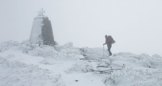
Thick snow blankets Omanui/McKinnon Pass
Conditions will be wet and cold with snow
During the winter months Fiordland can be very wet and cold. Daylight is limited and the high mountains let little sunlight into the valleys. Alpine areas are usually covered in snow. Dress for these conditions.
Flood risk
The Milford Track is not an all-weather track. Both the Clinton and Arthur Valleys become impassable due to flooding, during heavy rain.
Heavy rain increases the risk of landslides. In spring (September – November) the snowmelt makes the rivers and side streams come up even faster. Heavy rain also triggers avalanches, increasing avalanche risk.
There is no monitoring of weather forecasts and river levels outside of the Great Walk season. Trampers should monitor the severe weather on MetService for heavy rain in the Fiordland area.
If there is a heavy rain warning for Fiordland during your scheduled tramp dates, then you should make alternative plans, as the track will become flooded/impassable during heavy rain.
If the heavy rain warning is:
- for one day only – schedule an extra day / another night in a hut, so you are not walking on the track that day
- for more than one day – postpone your tramp until the weather improves.
Avalanches can be frequent
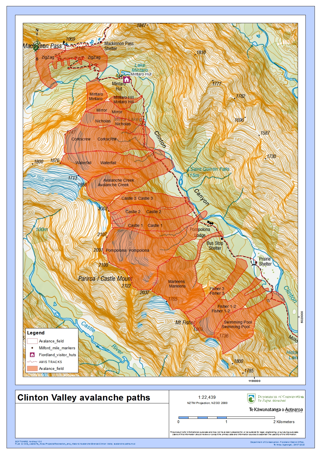
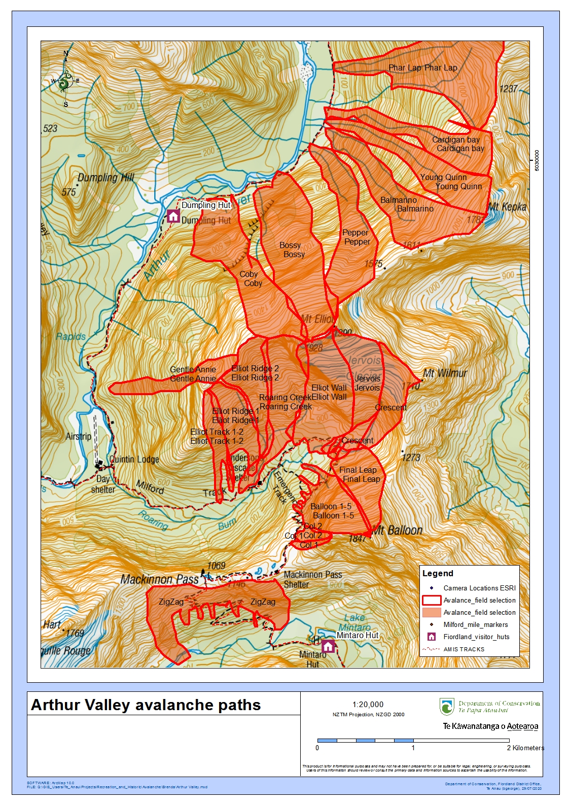
The Milford Track is mainly complex avalanche terrain. Avalanches are frequent. There are over 57 avalanche paths, which may bring avalanche debris to the valley floor. Some of these have the potential to cross the Milford Track – their start zones cannot be seen from the track.
If you are going into places avalanches could occur, be sure you:
- have checked the New Zealand Avalanche Advisory for Fiordland and the Avalanche Terrain Exposure Scale (ATES) for Fiordland
- have the skills for the ATES class you are going into
- have talked to the Fiordland National Park Visitor Centre
- take an avalanche transceiver, avalanche probe and a snow shovel. Know how to use these tools.
Maps of avalanche paths: Clinton Valley avalanche paths (JPG, 1,742K) | Arthur Valley avalanche paths (JPG, 1,703K)
Expect reduced hut facilities
- Gas is not provided – you will need to bring your own cooking stove.
- Flush toilets are replaced with pit toilets.
- Running water is turned off inside the huts. Water can be obtained from the outside water tank; if this is frozen, then from the nearest water course or by melting snow.
- No rangers based at the huts.
Expect reduced transport services
All transport must be arranged before starting the track. During winter, transport operators require minimum numbers and do not always operate a daily service. Transport arrangements can be affected by bad weather. You must discuss an alternative option with transport operators before you begin your walk.
Contact a transport operator for information:
Be totally self-sufficient
You need to be totally self-sufficient. In addition to what to take in the Great Walks season, you also need:
- food for at least two extra days
- stove and gas for cooking
- lighter or matches
- alpine equipment: ice axe and crampons
- avalanche equipment: beacon, snow shovel, avalanche probe
- personal locator beacon
- satellite messenger (optional).
This is outside the Great Walks season.
- It can be cold and wet, with ice, snow, flooding and avalanches.
- Avalanche-prone bridges across some major watercourses are removed.
- DOC does not manage hazards such as flooding and avalanches.
- Facilities are greatly reduced.
Walking the track at this time should only be attempted by fit, experienced and well equipped people.
Mid-September to late October (Labour weekend) is before the Great Walks season. You can expect higher avalanche risk and unbridged streams that flood often.
It is a more risky and difficult experience – read the information below carefully and decide if it is right for you.
Side streams are unbridged and flood often – you may get trapped on the track
Bridges over side streams are not installed until the Great Walks season. You will need to cross these streams without a bridge.
They flood often, especially in spring due to snow melt. This means you could be trapped by side streams becoming impassable and need to shelter until the stream drops again. Pack an emergency shelter.
Make sure you know the signs of an unsafe stream and have good river crossing skills. How to cross rivers safely.
The track itself also floods
The Milford Track is not an all-weather track. Both the Clinton and Arthur Valleys become impassable during heavy rain, due to flooding. Heavy rain also increases the risk of landslides.
There is no monitoring of weather forecasts and river levels outside of the Great Walk season. Trampers should check the severe weather on MetService for heavy rain in the Fiordland area.
No one should try and walk the track during a severe weather warning/watch, and it’s best to avoid it in early-mid Spring if heavy rain is forecast.
There are avalanches in spring – check the avalanche forecast
DOC does not manage avalanche risk outside the Great Walks season.
The Milford Track is mainly complex avalanche terrain. Avalanches are frequent. There are over 57 avalanche paths, which may bring avalanche debris to the valley floor. Some of these have the potential to cross the Milford Track – their start zones cannot be seen from the track.
- Check the New Zealand Avalanche Advisory for Fiordland and the Avalanche Terrain Exposure Scale (ATES) for Fiordland.
- Make sure you have the skills for the ATES class you are going into.
- Talk to the Fiordland National Park Visitor Centre.
- Take an avalanche transceiver, avalanche probe and a snow shovel. Know how to use these tools.
We strongly advise staying out of the upper valleys during heavy rain, when it is snowing, or on a hot day following new snow.
Maps of avalanche paths:
Plan for an extra day and a satellite communication device
Plan for an extra day on the track, so you are not on the track during a rainy day. If consistent rain is forecast for more than one day, we recommend changing your trip dates.
Do not book your flight home on the same day as you finish the track – rushing to get to a flight can lead trampers to make bad decisions about river crossings.
There is no cell phone reception on the Milford Track. Carry a distress beacon. Consider carrying a satellite communication device, such as an InReach, so you can communicate with your transport provider if you are delayed by weather.
Nature's in trouble
Thousands of New Zealand’s native species are heading towards extinction. Once they’re gone, they’re gone for good. Nature needs your help.
Stay safe in the outdoors
- Choose the right trip for you. Learn about the route and make sure you have the skills for it.
- Understand the weather. Check weather forecasts.
- Pack warm clothes and extra food. Check gear lists.
- Share your plans and take ways to get help. Leave your intentions with a trusted contact and take a distress beacon.
- Take care of yourself and each other.
Te Rua-o-te-moko/Fiordland National Park Visitor Centre
| Phone: | +64 3 249 7924 |
| Email: | fiordlandvc@doc.govt.nz |
| Address: | 1 Lakefront Drive Te Anau 9600 |
| Hours: | Visitor centre hours and services |