This unmaintained track begins from Carrington Hut.
Carrington Hut to Waimakariri Falls Hut
Distance: 7.6 km
Time: 3–5 hours
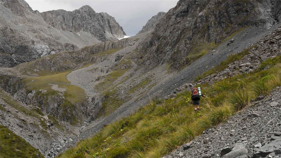
The tramp from Carrington Hut to Waimakariri Falls Hut passes through dramatic alpine scenery, with waterfalls running down sheer rock faces to gentle tarn-studded alpine herbfields. The upper beech forest edge and beginning of the alpine zone are only one hour from Carrington Hut.
Avalanche paths on this route
This route passes through several known avalanche paths. Avalanches can occur anytime there is snow on steep slopes. During heavy snow conditions, we recommend not using this route unless you’re sufficiently equipped and experienced to assess the snow conditions and choose a safe path through avalanche terrain.
Waimakariri Falls Hut is located in known avalanche paths. Avalanches are most likely to occur during and following heavy snowfall or rain when snow loading is present on the upper mountain slopes. Do not use this hut during these high-risk periods. Check Arthur's Pass avalanche forecast
Waimakariri Falls Hut to The Divide
Distance: 2.4 km
Time: 2–3 hr
From Waimakariri Falls Hut you can see a ravine and two lines of bluffs to its left. Travel up the true left to the ravine in the middle of the valley and cross the Waimakariri River below the ravine. Go up the scree between the two bluffs.
This will take you above the lower bluffs. Sidle to the right to get around the upper bluffs. The low point in the ridge where you cross is between Point 1845 and Mt Armstrong. Make your own way through bluffs to this point well to the northwest of Waimakariri Col.
Do not attempt to cross the divide at Waimakariri Col.
The Divide to Rolleston River Route
Distance: 2.7 km
Time: 4 hr
From the ridge, travel is down the stream draining the small glacier on the slopes of Mt Armstrong. The gully running parallel to the stream develops into a steep chute and should not be entered. Leave the stream where it begins to level out in the basin below.
Rolleston River has a series of steep gorges and waterfalls. Stay high above the true left of the river – sidle to the left well above Rolleston River. Sidle down to the knob near the bottom of the basin, a cairn may be present on top.
From the knob follow a worn trail down its ridge, through rocky outcrops. Stay high and do not drop onto the flattish tussocky terrace below. Instead, cross the first scree slope you come to. In a few minutes you will come to a small side stream. Cross this above its junction with the Rolleston River.
Climb the scrub covered slopes on the true left for around 100 m. Then sidle above the Rolleston River across areas of extremely steep scree, tussock and scrub, slowly descending with the fall of the river below for about 2 hours (1 km).
If there is snow around, there’s the possibility of avalanches. At the northern end of this long traverse is a narrow, boulder strewn scree slope, with scrub covered bluffs on its downstream side. Descend to the Rolleston River crossing to the true right. The marked Rolleston River Route is picked up here.
Below this point the Rolleston River becomes heavily gorged with several large and impassable waterfalls.
Rolleston River Route to Rail Bridge
Distance: 4.6 km
Time: 2 hr
The route climbs a short distance before sidling above the river for around 1.5 km ending at a scree slope. This slope is easily descended to the river.
Boulder hop downstream, crossing to the true left when the riverbed turns to shingle. Follow the KiwiRail access road out to SH73. Otira can be reached by walking about an hour from here.
This track begins from Carrington Hut.
If you want to start this route from the opposite end, go to the KiwiRail access road from SH73 south of Otira.
What to expect
A challenging alpine crossing with multiple hazards. The route is not marked or maintained by DOC between Waimakariri Falls Hut and Rolleston River.
You can expect to encounter:
- rugged terrain
- snow and ice anytime of the year
- avalanche paths that you have to cross
- steep descents over boulders, scree and scrub
Skills and experience you need
To do this trip, you need:
- to be experienced in backcountry alpine tramping, including being comfortable using crampons and an ice axe
- to be able to assess confidently the weather and avalanche conditions, and decide whether it is safe to proceed
- to have good navigation skills, able to navigate off-track and in poor conditions
- the gear to be self-sufficient in a remote alpine area
Without these skills, experience and equipment, you are advised not to travel this route.
Gear list
Pack to be fully self-sufficient, including an emergency shelter, survival kit, extra food and a distress beacon.
Alpine gear list:
- ice axe
- crampons
- avalanche transceiver, avalanche probe and snow shovel and the knowledge to use them.
Snow and ice may be present all year
Choose a good crossing point
Know your route well. The recommended crossing point is between point 1845 and Mt Armstrong as shown on the NZTopo 50 map (higher and further northwest of Waimakariri Col.)
Do not attempt to cross the divide at Waimakariri Col.
Stay safe when crossing rivers
If you plan to cross unbridged rivers, know how to cross safely and be prepared for if you cannot cross.
Do not cross if the river is flooded, you cannot find safe entry and exit points or are unsure it’s safe. Turn back or wait for the river to drop. If in doubt, stay out.
NIWA river flow forecasts: View a video of national followed by regional river flows
Stay safe in the outdoors
- Choose the right trip for you. Learn about the route and make sure you have the skills for it.
- Understand the weather. Check weather forecasts.
- Pack warm clothes and extra food. Check gear lists.
- Share your plans and take ways to get help. Leave your intentions with a trusted contact and take a distress beacon.
- Take care of yourself and each other.
Arthur's Pass National Park Visitor Centre
| Phone: | +64 3 318 9211 |
| Email: | arthurspassvc@doc.govt.nz |
| Address: | 104 West Coast Road Arthur's Pass 7654 |
| Hours: | Visitor centre hours and services |