22.1 km one way
Image gallery
Video
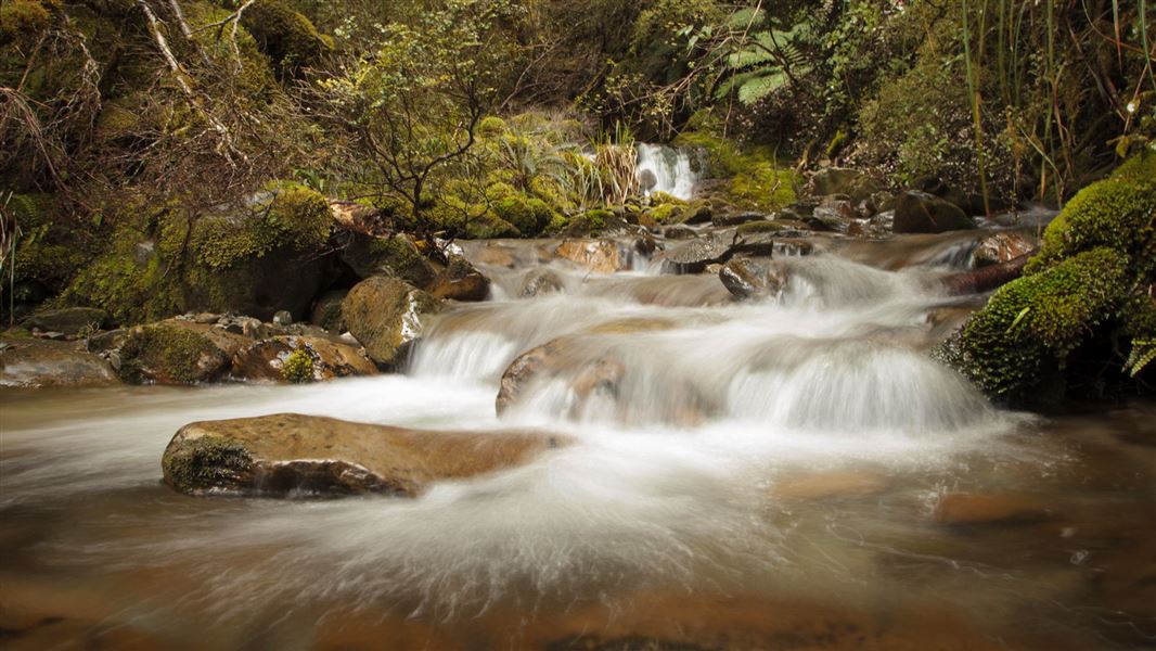
The Croesus Track crosses the Paparoa Range between Blackball in the Grey Valley and Barrytown on the Tasman Sea Coast. It's an ideal tramp for people new to tramping.
It's a beautiful walk into the landscape of the Paparoa Ranges. There is plenty of evidence of the local gold mining heritage and a variety of vegetation and wildlife. Croesus Track is one of the few pack tracks on the West Coast that ascends over 1000 m above sea level, and its high points provide excellent views of the Southern Alps and the sea.
It's recommended to walk from Smoke-ho carpark in the east to Barrytown in the west. In this direction, the track ascends to 1200 metres via a well-formed and fairly easy track. Part of Croesus Track is also part of the Paparoa Track. Croesus Track splits off from Paparoa track after the signposted turnoff toward Barrytown. Croesus Track, after this turn-off, is quite steep and rough before it descends onto a good benched track. Snow poles mark the route across the open tops and route-finding navigational skills are required.
Smoke-ho car park to Ces Clark Hut
Time: 4–5 hr
Distance: 10.3 km
For the first hour of the track, you will pass through mixed podocarp and beech forest and cross a wire suspension bridge over the Smoke-ho Creek. The track then zig-zags up the dividing ridge between Blackball Creek and Roaring Meg catchments for the next hour until you reach the turn-off to the Battery Track.
The track then climbs more steeply into subalpine forest leading towards Ces Clark Hut. You will pass the historic Croesus Top Hut just before reaching Ces Clark Hut. Croesus Top Hut is kept for historic purposes – you cannot stay at Croesus Top Hut. However, in an emergency, you can use it for shelter.
Ces Clark Hut is on the edge of the bushline, set among low alpine scrub and with spectacular views. On a fine day there are views of Lake Brunner, the main divide, and down to Aoraki Mount Cook.
Side trip: Garden Gully Track
Time: 45 min return
This track comes off the Croesus Track at Garden Gully junction. Five minutes down the track trampers can view an old miner’s hut dating from the 1930s depression. After crossing Roaring Meg Creek, a marked route leads to a century old quartz crushing battery. Allow approximately 10 minutes to reach the battery. Do not attempt to cross the creek if it has been raining or the flow is high.
Side trip: Croesus Knob Route
Time: 1 hr 10 min return
The turn-off to Croesus Knob is a 30 minute walk up from the hut. From the main track a rough route takes you up to the top where you are rewarded with spectacular views down to Mount Cook, and out to the Tasman Sea.
Ces Clark Hut to Barrytown
Time: 5–6 hr
Distance: 11.9 km
This stretch is advised for more experienced trampers – on the tops the track is not well marked and can be extremely difficult to see during certain times of the year. For the first 1 hour and 30 minutes follow Paparoa Track across the tops around the head of the Ten Mile Waianiwaniwa Creek.
Halfway across the tops, the Paparoa Track branches off to the right, while the Croesus Track to Barrytown sidles leftwards and climbs to the flanks of Mount Ryall (1220 m high). Along this stretch, you will also see views down the valley towards Aoraki Mount Cook and the Tasman coastline.
For the last 2 hours, 30 minutes the track is marked down the ridge. As you gradually descend, the vegetation changes from forest to nikau palms.
Take care of large slip: There is a large active slip on the Barrytown side of the track. A small bench has been constructed across the slip but take care especially following heavy rain.
The Croesus Track is Greymouth's premier mountain bike track.
Grade 4: Advanced
Length: 16 km (10 km from Smoke-ho carpark)
Time: 4 hr
Start point: Blackball Township or Smoke-ho carpark
End point: Ces Clark Hut
From Smoke-ho car park the ride up to Ces Clark Hut follows a very well preserved miners’ track that is excellent for mountain biking.
The trail has an achievable gradient with long rideable uphill sections. It is rocky and technical in places and more difficult to ride when wet and rainy. However, when you finally reach the hut the view is superb and the ride back down is phenomenal.
This is a shared-use track. Follow the mountain bikers code: respect others, respect the rules, respect the track.
Head north of Greymouth towards the Blackball township. About 1 km past Blackball on a sealed road to Roa mine is a signpost pointing right to Croesus Track Road. Go up this gravel road to Smoke-ho car park and to the start of Croesus Track. This is also the start of Paparoa Track when doing Paparoa Track from south to north.
The Croesus Track Road is not recommended for campervans.
View a map of the Croesus and Moonlight Pack Tracks (PDF, 831K)
Gear and equipment
Wear sturdy, comfortable tramping books.
Carry a Topomap NZMS 260 (1:50,000) series K31 Ahaura, a sleeping bag, cooking utensils, portable stove and fuel, sufficient food, basic first aid kit, raincoat, insect repellent and warm clothing including gloves and hat. Be prepared for sudden changes in the weather at any time of year.
Latest conditions
For track conditions, maps, weather forecasts and more information on the area contact the Māwhera / Greymouth DOC Office.
Dogs
The area around the Croesus Track is an important wildlife habitat – leave your dog at home as this will affect the recovery programmes for kiwi and blue duck.
Originally constructed in 1881, it is an old mining trail through the forest with many historic sites along the walk. The Croesus Track is one of the best surviving examples of a pack track in New Zealand.
In the early days of European settlement tracks known as ‘pack tracks’, ‘bridle paths’ or ‘bullock roads’ were built to open up the back blocks for mining, farming, tourism and other commerce.
Horses and bullocks were commonly used to access timber and mining sites, as well as transporting goods and equipment throughout the country. Many of the roads we use today started life as one of these early tracks.
Gold mining in the Grey Valley
When gold was found at Blackball Creek in 1864, miners formed a rough track up the creek, through what was known as ‘some of the roughest country ever travelled by man’ in the hopes of striking it rich.
Over 18 years from 1881 to 1899, this early track was slowly replaced by a pack track, now known as the Croesus track. Access was firstly improved to take miners to the Clarke Creek gold diggings, then through to the Blackball Creek forks, finally taking the track right through to miners’ gold claims in the Paparoa ranges.
Skilled craftmanship
The track was skilfully built, using various traditional building techniques such as stonework and cuttings. It required ingenious engineering solutions to tackle problems created by the steep slopes and rugged country.
Today the track survives in much of its original condition thanks to the skilled craftsmanship of early pioneers and the stable nature of the terrain.
Historic relics
Today the 2 day trail is enjoyed by trampers and mountain bikers who traverse the rugged bush clad terrain to open tops, and pass relics such as the 19th century alluvial workings and the impressive quartz mining remains at the Garden Gully Battery site. They can admire the fine workmanship used to build the cuttings, embankments and stonework which are displayed along the track.
Visitors can also experience what life was like for miners by visiting:
- historic Croesus Top Hut
- historic Garden Gully Hut.
You can visit these huts but you cannot stay overnight at them. This is to help preserve these historic places.
Historic Garden Gully Hut
Garden Gully Hut was built during the 1930s slump by men prospecting for the Government or employed on a subsidised gold scheme. It is a significant historic site - the sole survivor of five huts which stood in the Garden Gully during the 1930s.
The hut sits amid beech/podocarp forest in a grassy clearing with a stream nearby. You are not permitted to stay in the hut but you can camp on the adjacent grassy flats.
It contains bunks and has a large open fireplace with a corrugated iron chimney. It was fully restored in 2006, when the side walls were replaced by original treated calico.
The hut will be maintained to protect its historic fabric and minimise deterioration. A conservation plan has been prepared (Les Wright, June 1998) to guide its management. A hardcopy of this plan is available at the Greymouth-Manwheranui DOC Area Office.
The surrounding area
About 10-15 minutes walk from Garden Gully Hut is the impressive Garden Gully Battery Site.
An additional 10 minutes walk from the Garden Gully Battery turn-off is the Garden Gully Mine. This mine was owned by Gerald Perotti, the only one who had the legal right to move supplies from the Smoko-ho car park to the Garden Gully Mine. The mine was closed by 1906 because of lack of gold return. At the mine site you will see old railway lines collapsed from the tramway and other historic remains.
Historic Croesus Top Hut
The hut was likely to have been built during the 1930s depression when gold prospectors worked on the Paparoa Tops, however, there could have been an earlier hut on the site. The hut has corrugated iron cladding and is timber lined. Inside the hut are a table, three sacking bunks and an open fireplace.
To preserve its historic fabric, you’re not allowed to stay overnight in Croesus Top Hut. This helps prevent damage to the hut.
DOC restored the Top Hut in 1999 as the hut was to the point of near collapse.
Stay safe in the outdoors
- Choose the right trip for you. Learn about the route and make sure you have the skills for it.
- Understand the weather. Check weather forecasts.
- Pack warm clothes and extra food. Check gear lists.
- Share your plans and take ways to get help. Leave your intentions with a trusted contact and take a distress beacon.
- Take care of yourself and each other.
Paparoa National Park Visitor Centre
| Phone: | +64 3 731 1895 |
| Email: | paparoavc@doc.govt.nz |
| Address: | 4294 Coast Road Punakaiki RD 1 Runanga 7873 |
| Hours: | Visitor centre hours and services |