The area has several entry points, for example:
- Prospect Hill Track,
- Omeo Gully Track, and
- Symes Road.
Kopuwai has several vehicle entry points:
- the northern entrance is via the Nevis Road near Duffers Saddle
- the eastern entrance is either Symes Road or Waikaia Bush Road – Waikaia Bush Road closed in winter
- the southern entrance is via Whitecoomb Road – Piano Flat.
Several access routes cross private land. Respect livestock and property and follow the instructions on DOC signs. Leave gates as you find them and use stiles where they’re provided.
Winter access – roads impassable
Road access to Kopuwai Conservation Area is on dry-weather, largely un-maintained legal roads. In winter the roads become impassable because of snow and ground conditions.
This area is subject to weather extremes at any time of year and roads can become very wet and swampy. Check the weather forecast or contact Tititea/Mount Aspiring National Park Visitor Centre.
Weather
This area is subject to weather extremes at any time of year and roads can become very wet and swampy. Check the weather forecast or contact Tititea/Mount Aspiring National Park Visitor Centre.
Weather and fog: Temperatures at this altitude can change suddenly even in mid-summer. Take warm and windproof clothing. Fog can roll in quickly – take a map and GPS to help with navigation during the fog.
Avalanches: Be avalanche aware as this area has ‘simple’ avalanche terrain.
Leave what you find
Remember that all rocks, historic artefacts, native plants and animals are protected on public land. Tread carefully and take only photographs.
Kopuwai/Old Man and Old Woman Ranges run from north-west to southeast, creating a rain shadow that blocks and absorbs southerly fronts, making Central Otago New Zealand’s driest area.
Kopuwai became conservation land from tenure review outcomes and land purchase. The long summit crest is exposed and has an average annual temperature close to zero degrees celsius.
Geography
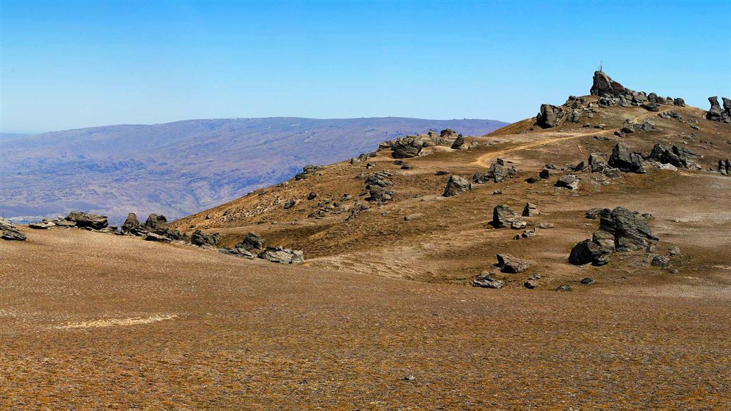
Kopuwai Conservation Area is around 20,000 ha and ranges from 800 m above sea level to 1,682 m. The highest point is at the Obelisk/Kopuwai on the Old Man Range. The ranges are dotted with distinctive schist rock tors and bisected by fields of freeze-thaw hummocks and mounds, creating a wave-like effect across the slopes and basins.
Nestled in the ranges are the headwaters and alpine basins of Campbell Creek and the Pomahaka and Fraser rivers. The ranges are also bisected by steep gullies that add to the area’s remarkable diversity. Hyde Rock is a short walk over a stile offers spectacular views.
Vegetation
The ground cover is dwarf, tundra-like vegetation of windblasted cushion plants. A low growing dracophyllum dominates these areas, along with several mountain daisies. Blue tussock is prevalent, with other small native grasses and occasional patches of taller, slim snow tussock. Lower down, narrow-leafed snow tussock is dominant.
Snow can linger for several months a year – wet snow banks host small cushion-forming herbs. There are larger wetlands of bogs, seepages and tarns in the headwaters of the Fraser River and Campbell Creek.
Bird life
The lower altitude scrubland hosts the grey warbler/riorio, silvereye/tauhou, Californian quail and other introduced birds. In open tussock:
- pipit/pīhoihoi
- South Island pied oystercatcher/tōrea
- banded dotterel/tūturiwhatu
- skylark
- redpoll, and
- yellowhammer.
The Australasian harrier/kāhu is common and the rare New Zealand falcon/kārearea both nests here and soars overhead.
Lizards and invertebrates
Kopuwai is a sub-alpine island for lizards and invertebrates including beetles, grasshoppers, weta, spiders and moths, many found nowhere else in the world. Individually and collectively they help maintain the natural balance of this unique landscape.
The area is rich in Māori and European history. Find out about the legend of Kopuwai, and about the European history of gold mining and farming in the Kopuwai Conservation Area.
History and culture of Kopuwai Conservation Area.
Discover the historic Whites Hut built on an old gold mining site.
Wānaka Tititea/Mount Aspiring National Park
Visitor Centre
| Phone: | +64 27 269 6871 |
| Email: | wanakavc@doc.govt.nz |
| Hours: | Visitor centre hours and services |