15 km one way from car park return via same track
This track is best hiked in dry weather in summer and early autumn.
Image gallery
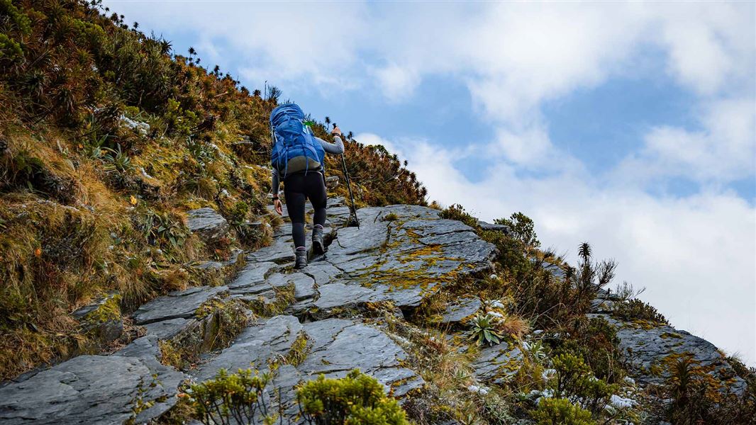
Liverpool Track is best suited to experienced hikers who are comfortable with high, exposed and technical tracks. You can expect:
• A steep, long climb from the valley floor to Liverpool Hut. At times you will be climbing up rocks and tree roots, pulling yourself up with your hands.
• Steep and slippery terrain where a fall could cause serious injury.
• Fast-changing alpine weather.
If this doesn’t sound right for you, Aspiring Hut is an easier overnight trip in Mount Aspiring National Park. It has options for side trips further up the valley or to see the Rob Roy Glacier.
Raspberry Creek car park to Aspiring Hut
Time: 2 hr – 2 hr 30 min
Distance: 9 km
The track starts at Raspberry Creek car park. Follow the West Matukituki Track up the valley to Aspiring Hut. The track is mainly through grassy farm flats, with a couple of small bluffs which give good views of the valley.
Aspiring Hut to Pearl Flat
Time: 1 hr 30 min
Distance: 5 km
The track enters the bush near Aspiring Hut. After 10 minutes a bridge crosses Cascade Creek, and a 1 km bush section emerges onto an open terrace leading to Shovel Flat.
The track has eroded at the head of Shovel Flat. Proceed with caution and allow extra time. Follow the orange poles towards the bush, instead of following the riverbank. After 400 m, you will reach Pearl Flat.
At Pearl Flat, turn off West Matukituki Track onto Liverpool Track, signposted to Liverpool Hut.
Challenging avalanche terrain between Rough Creek (just beyond Aspiring Hut) and the intersection with the Liverpool Track can make travel hazardous from late autumn to early summer. Move quickly through this area and be vigilant. Avalanche debris may reach the valley floor at Shovel Flat, so do not camp there.
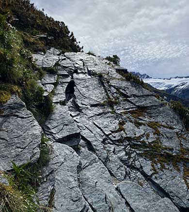
The track has steep, rock slab terrain to navigate.
Image: DOC
Pearl Flat to Liverpool Hut
Time: 2 hr - 2 hr 30 min
Distance: 1 km
From Pearl Flat, cross the swing bridge at Liverpool Stream. The track then leads up a long, steep and often slippery climb to the bushline. At the top of the bush, there is a rock slab to cross with a steep drop off on one side. This can be treacherous in wet or icy conditions – take care.
Above the bushline, the track initially leads across steep exposed shingle, rock and tussock. The track then goes left up an easier tussock slope to reach a knoll overlooking the hut.
Note: when the hut is first sighted, do not sidle across to the hut below this knoll as the terrain becomes extremely steep. Follow the poles to stay on the track.
There is no track beyond Liverpool Hut.
The track starts at the Raspberry Creek car park, 54 km west of Wanaka on the Wanaka-Mount Aspiring Road. The drive takes about 1 hour 20 minutes. The last 30 km are gravel.
There are several creeks to drive through in the last 10 km of the road. These rise in heavy rain and can become impassable to 2WD and sometimes 4WD vehicles. After 24 hours of little or no rain, the fords are usually passable for 2WD vehicles, including campervans.
Check the weather forcast on NIWA website.
Drive slowly through the fords and, if in doubt, get out of your vehicle to check the depth of them beforehand. If needed, you can park before the final two fords and walk the remaining few hundred metres to the car park – just make sure your vehicle is safely off the road and not blocking any farm gates.
After particularly heavy rain, the road is prone to washouts, sometimes requiring it to be closed for repairs.
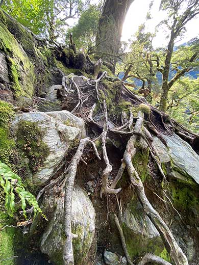
A tree root section on the track.
Image: DOC
Challenging track
The track is suitable for experienced hikers only with good fitness.
Weather
The track is best hiked in dry weather in summer and early autumn.
Check the weather before you go
In very heavy rain, creeks along the track, particularly at Shovel Flat, may become impassable.
Beyond the valley floor, rain, ice and snow all make the track surface much more slippery and so increase the risk of falls.
One section is particularly exposed with a slab of rock next to a steep drop – this is hard to cross if the rock slab is slippery and a fall could be fatal.
The weather changes fast and cold temperatures, snow, strong winds and heavy rain can occur at any time of the year. Always carry gear for bad weather.
Take the right gear
Hiking boots/shoes with good grip are essential. All hikers need to carry warm and waterproof clothing, including gloves and a hut.
Take plenty of food and water, plus gear for emergencies. Pack your own toilet paper as it’s not provided at the hut.
Overnight trampers will also need a sleeping bag and cooking gear (including a stove, fuel, and cooking equipment). There are no lights, fires or heaters provided at the hut so bring warm clothing.
The long climb is demanding and we recommend you pack lightweight food and gear. Find a packing list here:
Overnight and multi-day tramp gear list: Know before you go.
Snow and ice
These valleys aren’t closed in winter, but snow can make travel difficult and dangerous. Mountaineering experience, including using an ice axe, crampons and avalanche rescue equipment, is needed in winter, and sometimes in spring and autumn. The snow can be as low as the bushline as late in the year as December, and as early as April. Ask the Wānaka Visitor Centre staff about current conditions.
If snow or ice is still present on the alpine section of the Liverpool Track in spring or early summer, the track is not recommended without ice axe and crampons and the experience to use these.
Be avalanche alert
Avalanches can occur in any season. Any time that snow and steep slopes are combined there is potential for an avalanche. You need to understand the risks before you visit avalanche-prone country.
This area has terrain that can produce avalanches that cross the track, usually from May into November. View avalanche information and the terrain rating for this track.
Swing bridges
There's a limit to the number people allowed on the swing bridges at any one time – be prepared to wait at each end if numbers allowed have been reached.
Stay safe in the outdoors
- Choose the right trip for you. Learn about the route and make sure you have the skills for it.
- Understand the weather. Check weather forecasts.
- Pack warm clothes and extra food. Check gear lists.
- Share your plans and take ways to get help. Leave your intentions with a trusted contact and take a distress beacon.
- Take care of yourself and each other.
Wānaka Tititea/Mount Aspiring National Park
Visitor Centre
| Phone: | +64 27 269 6871 |
| Email: | wanakavc@doc.govt.nz |
| Hours: | Visitor centre hours and services |