Image gallery
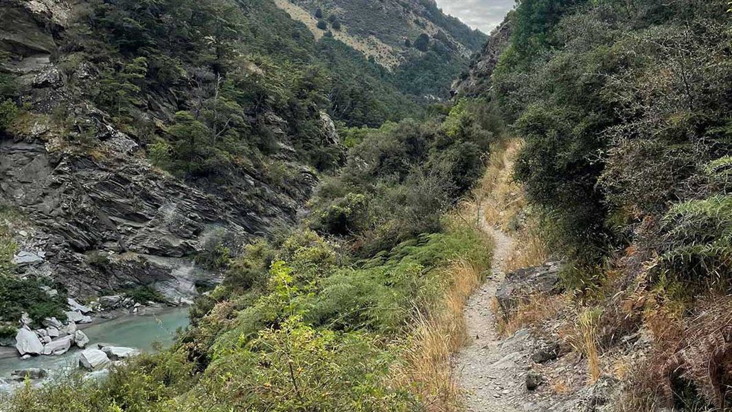
Lower Tīmaru River Track involves numerous river crossings that should not be attempted if the river is high. There are several steep sidles which require care, other sections are rough and uneven.
The marked track starts on the Tīmaru River's true left and crosses it several times during the first hour.
It then crosses open flats near Junction Hut (private). The going becomes more awkward, but the track is clearly marked. It progresses through heavily gorged sections around side streams, and along scree slopes. A slip on a section of track 50 m downstream from the Tīmaru River/Breast Hill track junction requires care when crossing, as it is a bluffy section with a vertical drop on one side.
Lower Tīmaru River Track ends at the junction with the Breast Hill Track (part of Te Araroa).
Alternative route/loop option: Tīmaru High River
This is a high river advanced tramping track.
It is signposted 50 m along the road and leads to a 4WD track above the Tīmaru River. Follow this undulating track to Deer Spur Creek near Junction Hut (1.5 km), cross the river and join the Lower Tīmaru River track.
River crossing skills are required. The loop track may not be possible after heavy rain. We recommend choosing another track when rain is forecast.
Walking Tīmaru High River Track then returning back to the car park via Lower Tīmaru River Track is a 4-5 hour loop trip.
The carpark at the start of the Tīmaru River Track is 10 km from Lake Hāwea Township, on the unsealed Tīmaru River Road.
This is a challenging track with river crossings and steep drops
The track is a marked tramping track (follow the orange triangle track markers). It is narrow and uneven, including crossing sections of scree (loose gravel) and places with a steep drop of the side of the track.
There are many unbridged river and stream crossings. These should not be attempted if the river is high.
Check to make sure it is right for you. Isthmus Peak Track is an easier alternative day walk.
Bad weather
The weather can change rapidly in New Zealand. Hypothermia is a real risk even in summer. Be prepared by having warm, waterproof, windproof clothing and the appropriate footwear. Whiteout conditions caused by snow or low cloud may be present.
Check the Breast Hill forecast: Southern Lakes Forecast | MetService
Pack well for this tramp
You need to be well-equipped, even on a day walk. Pack plenty of warm and waterproof clothing and carry a distress beacon.
Check our Day Hikes gear list and DOC multi-day tramping packing list
Access through high country stations
These tracks cross working high country stations. Respect livestock and property and stay on the marked track. Dogs are not allowed on these tracks.
Hunting
Hunters may carry unloaded firearms on these tracks, if they have a current hunting permit for lands administered by DOC. Under no circumstances should hunters discharge firearms before entering permitted hunting areas.
Stay safe when crossing rivers and streams
If you plan to cross unbridged rivers or side streams, know how to cross safely and be prepared for if you cannot cross.
Do not cross if the river or stream is flooded, you cannot find safe entry and exit points or are unsure it’s safe. Turn back or wait for the river to drop. If in doubt, stay out.
NIWA river flow forecasts: View a video of national followed by regional river flows
Stay safe in the outdoors
- Choose the right trip for you. Learn about the route and make sure you have the skills for it.
- Understand the weather. Check weather forecasts.
- Pack warm clothes and extra food. Check gear lists.
- Share your plans and take ways to get help. Leave your intentions with a trusted contact and take a distress beacon.
- Take care of yourself and each other.
Wānaka Tititea/Mount Aspiring National Park
Visitor Centre
| Phone: | +64 27 269 6871 |
| Email: | wanakavc@doc.govt.nz |
| Address: | 1 Ballantyne Road Wānaka 9305 |
| Hours: | Visitor centre hours and services |