4.4 km to the summit, 13.7 km loop
The Pylon Peak Summit Track offers views of Mt Te Aroha and Hauraki Plains. Its long and steep sections require a good level of fitness, especially towards the ridge and summit.
The Pylon Peak Summit Track is accessed from the Low-Level Track, which starts at the carpark at the end of Waiorongomai Valley Road. Walk 5 minutes to the signposted junction about 130 m along the Low-Level Track, then cross the stream.
Take the forested track, which follows an old water race, winding up the hill to the ridge and summit. Along the way, look out for the remains of the old power pylons, which took power from a hydro dam near Lake Karapiro to the Victoria Battery near Waikino.
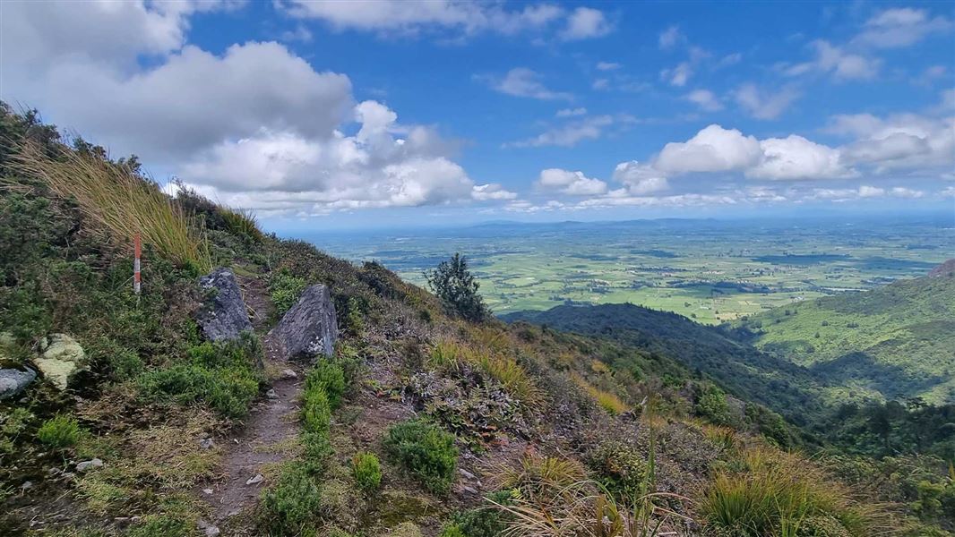
After around 2 hour 30 min, you reach the junction with the North South Track. There are excellent views of the Waikato, Mt Te Aroha and the Hauraki Plains.
From here, return down the Pylon Peak Summit Track the way you came.
Loop alternative (more advanced and longer option)
You can take a loop by following the North South Track, Waipapa Track/Crimson Thread Track and Waiorongomai Valley tracks. It is 4-5 hours from the junction with the North South Track, taking this loop option.
From the junction of the Pylon Peak Summit Track and the North South Track, take the left-hand branch of the North South Track and follow it along the Kaimai range (towards Mt Te Aroha). This is a marked route rather than a formed track but ensure you follow the markers at all times.
Follow this route until you reach the junction with Waipapa Track. Take the left-hand branch of the track (towards Te Aroha and Waiorongomai, not towards Waitawheta Hut). Follow this track as it descends to the Waiorongomai Saddle.
From the saddle, turn off the ridge and descend into Waiorongomai Valley on the Te Aroha Link track. Follow the signposts to return back to the car park (there are various track options through Waiorongomai Valley).
From Te Aroha, travel south for approximately 5 km on Te Aroha Gordon Rd then turn left into Waiorongomai Rd.
The track starts from the carpark at the end of Waiorongomai Rd.
Pack well for this walk
This is a strenuous half day/day walk. Carry warm layers, pack a waterproof raincoat and wear sturdy boots with good grip.
Find a day hike packing list here.
Know what to expect if you are doing the loop route
The North South Track is an expert-level tramping track. It has sections that are unmarked and overgrown, and is suited for experienced backcountry trampers only.
Read more about the North South Track
Be safe around historic mines
Mine tunnels and shafts are very dangerous and may be hidden by vegetation. To enjoy this place safely:
- Keep to official marked tracks
Do not enter tunnels unless they are clearly marked for public access

No mountain biking
Mountain biking is not allowed on this track.
Stay safe when crossing rivers
If you plan to cross unbridged rivers, know how to cross safely and be prepared for if you cannot cross.
Do not cross if the river is flooded, you cannot find safe entry and exit points or are unsure it’s safe. Turn back or wait for the river to drop. If in doubt, stay out.
NIWA river flow forecasts: View a video of national followed by regional river flows
No dogs
Dogs are not permitted on this track.
Lock your car and leave valuables out of sight
The car park is located in a remote location so its important your vehicle is left secured. Make sure it is locked and that all valuables are out of sight.
Pylon Peak
The Pylon Peak Summit Track still has a few remains of the steel power pylons that were used for the power line linking the Horahora hydroelectric power station with the Waihi Gold Mine and Victoria Battery, Waikino. The power station was built in 1913, making it the first large power station to be built in the North Island.
Waiorongomai goldfields
A prospector, Hone Werahiko found gold in the Waiorongomai Valley in 1881. The goldmines were never very successful - expensive engineering projects failed due to low yields from the unexpectedly hard rock of the enormous gold bearing reef. One of these projects was the Piako County Tramway which is a feature of many of the walks.
Stay safe in the outdoors
- Choose the right trip for you. Learn about the route and make sure you have the skills for it.
- Understand the weather. Check weather forecasts.
- Pack warm clothes and extra food. Check gear lists.
- Share your plans and take ways to get help. Leave your intentions with a trusted contact and take a distress beacon.
- Take care of yourself and each other.
DOC Customer Service Centre
| Phone: | 0800 275 362 |
| Email: | taurangainfo@doc.govt.nz |
| Address: | Tauranga Office |