
Image gallery
Video
Brochures
For Blue Lake see the Travers-Sabine Circuit brochure (PDF, 5,202K)
This track is part of Te Araroa Trail.
Waiau Pass Route is a very technical pass that requires a high level of tramping experience.
Watch the NZ Mountain Safety Council’s walk-through video which takes you through how to prepare for this track. Including facilities, key decision points, hazards and typical conditions for the area.
To tramp this route, you need to be completely self-sufficient, have above-average fitness, and have good navigation, river crossing and survival skills.
Blue Lake Hut to Waiau Hut
Time: 9-12 hr
Assess the weather before starting the ascent over Waiau Pass. Only attempt the pass in good weather – if the weather is bad, we recommend waiting in Blue Lake Hut and trying the pass another day.
Start early, as you should allow 9-12 hr to cross the pass and reach Waiau Hut.
Blue Lake Hut to top of Waiau Pass
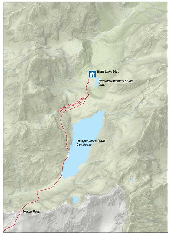
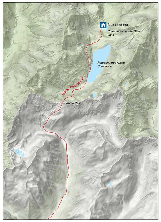
From Blue Lake Hut follow the signs, orange triangle makers and orange poled route which lead you south. The route climbs the moraine which is damming Rotopohueroa/Lake Constance.
Once on top of the moraine, follow the marker poles which lead high above the cliffs on the western side of the lake. Do not follow the lake edge – you will eventually get stopped by impassable bluffs and deep water and have to turn back.
The route around the cliffs above Rotopohueroa/Lake Constance will lead you through some steep guts and spurs. It then drops back down to the lake edge (approximately 2.7km from the hut) and follows the shoreline to the lakehead.
 Waiau Pass Route leads high above the cliffs on the western side of the lake
Image: DOC
At the lake’s northern end, follow the route along the valley floor for approximately 1km, with several stream crossings. The route then turns to the left (south) and starts to climb scree and steep rocky sections to Waiau Pass. It is approximately 1.5 km from the valley floor to the saddle and you gain 530 m in altitude. Hard icy snow can remain until December in these last 150+ metres of elevation, which can be very difficult to negotiate if the conditions are unfavourable.
Top of Waiau Pass to Upper Waiau Forks
Be aware that this section from the top of the pass to the valley floor is very steep and technical, even on a good day. There are many places where it is possible to slip or get stuck, particularly when there is snow and ice.
From the top of the pass, assess the conditions on the south side of the pass. Snow can be present at any time of the year – if there is snow, then do not proceed unless you have an ice axe, crampons and avalanche rescue equipment (and know how to use them). Return to Blue Lake Hut instead.
Follow the orange markers down from the Waiau Pass summit, ensuring you stay on the marked route. The route leads to the right from the summit, rather than descending directly into the valley. The descent is steep and rocky, so take your time and watch your footing.
 Waiau Pass Route leads to the right from the summit
Image: DOC
When you reach the valley, the route leads down the west branch of the Waiau Uwha River. It descends through scrub, then crosses the east branch of the river not far above the forks.
Upper Waiau Forks to Waiau Hut
Follow the route down the true left of the river, passing through a camping spot in a stand of beech and through a natural clearing. The route then crosses to the true right of the Waiau Uwha River and continues following it downstream.
Take care as the track may be overgrown in places. It is essential you follow the orange markers to follow the best route.
You will cross various side streams on the way down the valley, the largest of which is Caroline Creek. It is approximately 4 hours from Waiau Forks to Waiau Hut.
Topographic maps and the Mountain Safety Council video about the Waiau Pass Route include information about Caroline Creek Bivvy. This bivvy has been removed, there is no shelter or hut at this site. The nearest shelter is one hour downstream from Caroline Creek at Waiau Hut.
Waiau Hut to Christopher Hut
Time: 6 hr 30 min
Distance: 17 km
From Waiau Hut, continue following the Waiau Uwha River downstream on the true right bank. The valley gradually widens and you cross two old, bush-covered terminal moraines.
The route continues down the valley, mainly over broad, grassy river flats, until you reach the junction of Waiau Uwha River and Ada River. At the point where the two valleys meet, you will come to a track junction. Take the right-hand track across to Ada Valley, rather than continuing down the Waiau Valley.
Follow this track across the river flats and upstream on the true left of the Ada River. Cross the Ada River at the point opposite Christopher Hut. The hut is situated close to the edge of the bush.
Alternate Route from the junction on Waiau and Ada Rivers: Rather than taking the route to Lewis Pass, you can instead follow the St James Walkway south, walking through to Boyle Village. Follow the track downstream from the turnoff to the Ada Valley, crossing various side streams then the Ada River. Cross Ada Flat then Delta Stream, then the track will join the St James Walkway. Visit the St James Walkway page for a description from this point.
Christopher Hut to Ada Pass Hut
Time: 4 hr 30 min
Distance: 10.5 km
This section of the track is on St James Station. From Christopher Hut, follow the track upstream on the true right of the Ada River. Around 10-15 minutes from Christopher Hut, you will pass the historic Christopher (Ada) Cullers Hut.
Continue following the track upstream, though open areas of tussock with patches of mountain beech. Orange triangles at the clearing edge indicate the track through bush areas.
The track then enters the bush and crosses Ada Pass. Shortly after the pass you will reach Ada Pass Hut.
Ada Pass Hut to Cannibal Gorge Hut
Time: 1 hour 30 min
Distance: 3 km
The track follows an easy grade down the Maruia River valley, through beech forest and open alpine fields. Be aware that these open spaces are prone to avalanches.
Cannibal Gorge Hut to Boyle Village (Lewis Pass)
Time: 3 hr 30 min
Distance: 7 km
From Cannibal Gorge Hut, the track follows the true right of the Maruia River through bush. After around 6 km, a swing bridge crosses Cannibal Gorge to the true left back of the Maruia River.
The track then climbs in a steep zigzag, ascending 150 m of height. The track leaves the bush and meets the Alpine Nature Walk. This short track leads through an alpine wetland with spectacular views of Gloriana Peak and the Spenser Mountains. It ends at the state highway and Lewis Pass.
This route begins at Blue Lake Hut in Nelson Lakes National Park. This is already a very remote hut – to reach it, you need to walk the Travers-Sabine Circuit track and take the side trip to Blue Lake Hut.
Alternatively, you can begin this route from Lewis Pass or from Boyle Village (via the St James Walkway).
Waiau Pass is a very technical alpine crossing
You need backcountry and snowcraft experience for all seasons.
Waiau Pass is a difficult alpine crossing suitable for experienced parties only. Watch the Mountain Safety Council video about the pass and decide whether it is right for you and your group.
Weather conditions can deteriorate rapidly and icy snow conditions can be present at any time of the year. Snowcraft experience is required and equipment taken should include at least an ice axe and crampons.
The best time to attempt this trip is between December and April, it is not recommended in winter or spring.
There are substantial avalanche risks on Waiau Pass Route
Waiaua Pass is complex avalanche terrain with significant avalanche risks. Dangerous avalanches occur regularly in this area. You need avalanche skills and equipment if you are attempting the pass from May to December.
If there is snow on the south side of Waiau Pass, do not continue unless you have an ice axe, crampons and avalanche rescue equipment (and know how to use them).
There is also avalanche terrain on other parts of the route, including on the St James walkway, Waiau valley above the Caroline Bivvy site, the track to Blue Lake Hut and the Travers Sabine Circuit. Find information about avalanche terrain in Nelson Lakes and St James Conservation Area.
Talk to the staff at the Rotoiti/Nelson Lakes Visitor Centre about the latest snow and track conditions, and check the NZ Avalanche Advisory.
This is a remote track – pack to be self-sufficient and carry a distress beacon
This is extremely remote tramping, always carry a distress beacon.
It is very common for trampers to be delayed on this trip – even in the height of summer, people often have to wait extra nights at Blue Lake Hut until conditions are right to cross Waiau Pass. Everyone tramping this route should carry enough extra food for several extra days.
Carry an emergency shelter in case you are trapped by high rivers and need to shelter while waiting for them to drop.
Stay safe when crossing rivers and streams
If you plan to cross unbridged rivers or side streams, know how to cross safely and be prepared for if you cannot cross.
Do not cross if the river or stream is flooded, you cannot find safe entry and exit points or are unsure it’s safe. Turn back or wait for the river to drop. If in doubt, stay out.
NIWA river flow forecasts: View a video of national followed by regional river flows
There is no longer a bivvy at Caroline Creek
Caroline Creek Bivvy still appears on topographic maps and in some visitor information about Waiau Pass Route. This bivvy has been removed, do not rely on it for shelter. Continue on to Waiau Hut or camp in Waiau Valley.
Respect Rotomairewhenua/Blue Lake and Rotopōhueroa/Lake Constance
Rotomairewhenua/Blue Lake and Rotopōhueroa/Lake Constance hold high cultural significance to Māori, particularly Ngāti Apa ki te Rā Tō iwi. The lakes are tapu (sacred) and restrictions are placed on these lakes to uphold their mauri (life force) and purity.
Show respect by not touching the water. Do not swim, wash, take water or put any equipment into these lakes. This will also help keep the lakes free of the invasive lindavia (lake snow) that is present in Lakes Rotoiti and Rotoroa.
Stay safe in the outdoors
- Choose the right trip for you. Learn about the route and make sure you have the skills for it.
- Understand the weather. Check weather forecasts.
- Pack warm clothes and extra food. Check gear lists.
- Share your plans and take ways to get help. Leave your intentions with a trusted contact and take a distress beacon.
- Take care of yourself and each other.
Arthur's Pass National Park Visitor Centre
| Phone: | +64 3 318 9211 |
| Email: | arthurspassvc@doc.govt.nz |
| Address: | 104 West Coast Road Arthur's Pass 7654 |
| Hours: | Visitor centre hours and services |