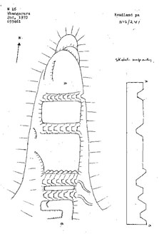
Waikare Historic Reserve is a narrow headland on the southern side of the Waikare Inlet, Opua in the Bay of Islands.
Access to the pā is by boat only from the southern side of Waikare Inlet. There is no track leading to the pā.
The pā that covers Waikare Historic Reserve has a massive defensive system of 5 transverse ditches, and a possible smaller sixth ditch. The largest ditch is 8m wide and 5.5m deep.
The traditional name of the pā and the bay to the east is said to be 'Te Kapa', which means front rank, or row of the haka.
The area is said to have belonged to Chief Te Kapa who fell off this point during battle manoeuvres.
The pā is reportedly from the 18th century, possibly 1750. It was likely to have been un-inhabited in 1845 when the British destroyed the other Kapotai pā and Pomare's pā located along the Waikare Inlet, Opua, at the beginning of the Northland wars.
This is a very impressive pā site in a little visited part of the Bay of Islands.
The site today is covered in pine, which acts as a canopy protecting the earthworks of the pā.
References
The Story of the Bay of Islands Maritime and Historic Park. 1989. Department of Conservation.
DOC Customer Service Centre
| Phone: | 0800 275 362 |
| Email: | bayofislands@doc.govt.nz |
| Address: | Pewhairangi / Bay of Islands Office |
