Atene Skyline Track
Located in Whanganui National Park in the Manawatu/Whanganui region
|
Introduction
The Atene Skyline Track has spectacular views and a campsite for trampers wanting to stay the night.12.5 km one way
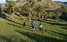
Dog access
Beginning at the up-river end, the track climbs steeply from the River Road to a height of 260 m through fine lowland forest. Following an old, gently graded roadline for around 3 km the track follows the ridgeline to a clearing which marks the track's halfway point. A campsite with drinking water, a shelter and a toilet is available here.
Shortly beyond this point is the Taumata Trig, the highest point of the track at 572 m. The track then winds around the edge of sandstone bluffs to reach Taupiri Trig before descending steeply back to the River Road.
Note that this track is not a complete loop. It's an extra 2 km walk along the road to return to the carpark.
The two entrances to this almost circular track begin on the Whanganui River Road, 36 km from Whanganui. Both entrances to the track are less than 2 km apart.
- Fires – fires are not permitted in Whanganui National Park.
- Weather conditions – track users are urged to observe the weather conditions and seek advice as wet, slippery conditions may be experienced at times, particularly during winter and early spring.
- Communications – this area is remote with no cell phone coverage. It is recommended that you carry an emergency alert device (e.g. PLB/Spot tracker).
- Dropoffs – there are multiple dropoffs on this track. Care should be taken while passing these.
- Windfalls – there may be windfalls on the track after weather events. Care should be taken while going around the fallen trees.
- Water – during dry periods, extra water should be carried as the shelter water may be dry or stagnant. Treat or boil all water before drinking.
- Wasps – wasps are a known hazard and are particularly common from January until May. Carry antihistamine if you are allergic to their stings.
The focus throughout the walk is Puketapu hill. Many hundreds of years ago the hill stood at the end of a long, narrow-necked peninsula. The river once flowed in an almost complete circle around Puketapu but after years of erosion the river broke through the neck, forcing a more direct route to the sea and cutting off the meander.
Spectacular views from vantage points along the track include the cut-off meander, the Whanganui River, Mt Ruapehu, Mt Taranaki/Egmont, the Tasman Sea, and the Whanganui River's tributary valleys.
Stay safe in the outdoors
- Choose the right trip for you. Learn about the route and make sure you have the skills for it.
- Understand the weather. Check weather forecasts.
- Pack warm clothes and extra food. Check gear lists.
- Share your plans and take ways to get help. Share directly or use the Outdoor Intentions form or Plan My Walk. Take a distress beacon.
- Take care of yourself and each other.
Contacts
| Whanganui Office | |
| Phone: | 0800 275 362 |
| Fax: | +64 4 471 1117 |
| Email: | whanganui@doc.govt.nz |
| Address: |
34-36 Taupo Quay Whanganui 4500 |
| Postal Address: |
Private Bag 3016 Whanganui 4540 |
| Full office details | |