Macaulay River valley - Macaulay Hut
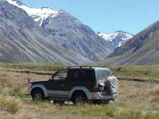
Macaulay River valley
Distance: 18km
From the Lilybank road end, ford the Macaulay River and follow the DOC signs for Macaulay Hut. Orange trail markers denote permanent sections of four-wheel track and the best places to cross the river.
Macaulay Hut is located on the lower Tindill fan and is run by the Mackenzie Alpine Trust.
Please end your trip here, as the upper valley beyond the hut has many fragile areas which are easily damaged by vehicles.
Godley River valley (east side) - Separation Stream
Distance: 30km
From the Lilybank road end, cross the Macaulay River to reach a marked public-access route through Lilybank Station. A four-wheel drive track follows the east side of the Godley valley for 25km to Red Stag Hut.
From here it is a further 5km to Separation Stream (the track is rougher in condition). It is one-hour walk from Separation Stream to Godley Hut, situated on the true right of Fitzgerald Stream, above the glacial-terminal lake.
These tracks involve river crossings so caution and skill are vital. In route descriptions true left or true right denotes the side of the river when facing and looking downstream.
The Godley river 4WD route has been destroyed by the river which has moved to the true left above Sibbald Island.
Vehicle travel beyond this point is at your own risk and may involve fording one or more braids of the river. It should not be attempted unless you are capable of self recovery.
Aoraki/Mount Cook National Park Visitor Centre
| Phone: | +64 3 435 1186 |
| Email: | mtcookvc@doc.govt.nz |
| Address: | 1 Larch Grove Aoraki/Mount Cook 7999 |
| Hours: | Visitor centre hours and services |