18 km return via same track
Hawdon Hut Track
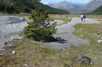
Image: DOC
This track begins at the Hawdon Shelter Campsite, accessed from Mt White Road. Follow the track for about 50 m and head straight out into the riverbed of the Hawdon River. This is where you'll find the easiest crossings of the lower Hawdon River. If the river is not easy to cross you will have problems further on, so save the trip for another day.
Cross the river and continue along the track through open terrain. After crossing the stock fence and the Sudden Valley Stream, the track enters the forest for about 3 km.
When you leave the forest, the track returns to the riverbed. A second crossing of the Hawdon River is required. Once on the other side, follow the marked 4WD track until you reach the crossing of the East Hawdon River.
About 1 km upstream, you'll need to cross the Hawdon River a third time. From there, the track remains mostly within the forest, with a few short sections along the riverbed.
Approximately 200 m before reaching the hut, you'll make the final river crossing – Discovery Stream. This the last river crossing of the journey.
Follow SH73 to the signposted turnoff to Mt White Road. Then follow the gravel road over the bridge and take the first left to Hawdon Valley. The track starts at Hawdon Shelter Campsite.
Plan for river crossings
There are numerous river crossings along this route. Do not attempt this track during and after heavy rainfall. Rivers and major side streams can rise quickly and become dangerous.
Ensure you have the latest weather information and that you are confident in assessing rivers and knowing how to cross them safely.
How to cross rivers safely - Mountain Safety Council website
DOC markers may not indicate the safest crossing point. You may need to walk upstream or downstream to find a more suitable place to cross.
If travelling this route during rainy weather take spare food in case you are stuck in the hut by rising river levels.
DOC staff use 4-wheel motorbikes to access the valley to protect the endangered kakariki/orange-fronted parakeet. Coloured markers and tape in the valley mark access points for DOC staff. Do not follow these markers. Follow only the standard orange track markers.
The Hawdon Valley is home to some of Aotearoa’s most endangered wildlife, including the orange-fronted parakeet/kākāriki karaka, great spotted kiwi/roroa, blue duck/whio, rock wren/pīwauwau, and yellowhead/mohua. This diverse valley provides a rare sanctuary for species that are found in only a handful of places across the country.
Thanks to ongoing intensive predator control, the Hawdon Valley is one of just five known locations in New Zealand where the critically endangered orange-fronted parakeet survives in the wild. Its close relative, the yellow-fronted parakeet/kākāriki kakariki kōwhai, is also present and is more commonly seen.
Stay safe in the outdoors
- Choose the right trip for you. Learn about the route and make sure you have the skills for it.
- Understand the weather. Check weather forecasts.
- Pack warm clothes and extra food. Check gear lists.
- Share your plans and take ways to get help. Leave your intentions with a trusted contact and take a distress beacon.
- Take care of yourself and each other.
Arthur's Pass National Park Visitor Centre
| Phone: | +64 3 318 9211 |
| Email: | arthurspassvc@doc.govt.nz |
| Address: | 104 West Coast Road Arthur's Pass 7654 |
| Hours: | Visitor centre hours and services |