
Monitoring takahē
Introduction
How we follow bird survival and habitat use.![]()
We use a combintation of smart transmitters, SkyRanger GPS recorders, and surveys to monitor our takahē.
Monitoring with smart transmitters
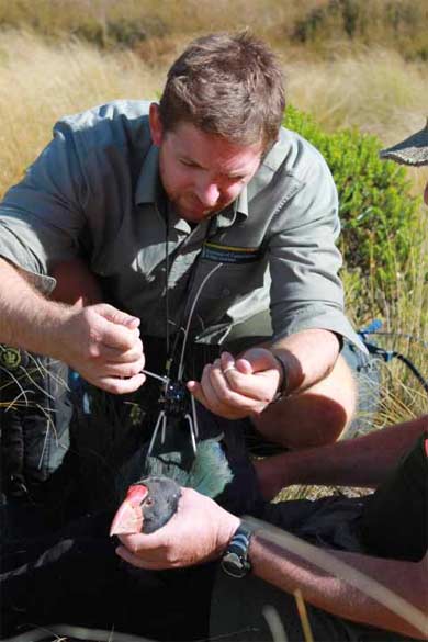
Fitting a transmitter with a flight harness
Image: H Dodson
To help keep track of individual takahē and build-up a picture of what is happening to the wild population, around half the adult birds wear small smart transmitters.
These transmitters send out radio signals which show a bird's location and whether it is alive or dead or has dropped its transmitter.
Sky Ranger
The smart transmitters allow the birds to be monitored remotely via an aircraft fitted with a receiver (Sky Ranger).
The fixed wing plane flies a grid pattern over the mountains carrying a Sky Ranger GPS recorder, which logs the location and 'state' of each of the birds carrying a transmitter.
Once back on the ground, the information is downloaded and assessed. This information is contributing to an on-going study of adult takahē survival and dispersal in the Murchison Mountains.
2017 Murchison Mountains Takahē Survey
In November and December 2017, the Takahē Recovery team completed a full survey of the takahē population in the Murchison Mountains.
This was the first full survey completed since 2014, and allowed for population estimates from the Sky Ranger monitoring to be 'ground-truthed' to ensure they're providing an accurate picture of trends in takahē population.
Small teams of DOC rangers searched the known territories for any sign of takahē. Mostly these are in basins and above the bushline, and at times travel between territories can be arduous. Luckily takahē leave lots of feeding signs, and up to 9 metres of droppings per day (especially during spring when pairs are nesting and not moving much).
The good news – the results of the survey matched those of our Sky Ranger flights.
For more information of the survey and the results read this three part blog series:
The next full Murchison Mountains population survey is scheduled for 3–5 years time. Any wild reared birds caught will also be given a unique leg band code and name, and recorded in the takahē database.