
Current restoration work
Introduction
These restoration activities are underway to support Ko te Whakahaumanu o te Rakitata Awa – the Rakitata River revival programme.As at July 2023 work across all sites has seen:
- 125 km of riparian fencing installed
- 200,000 plants in the ground and maintained
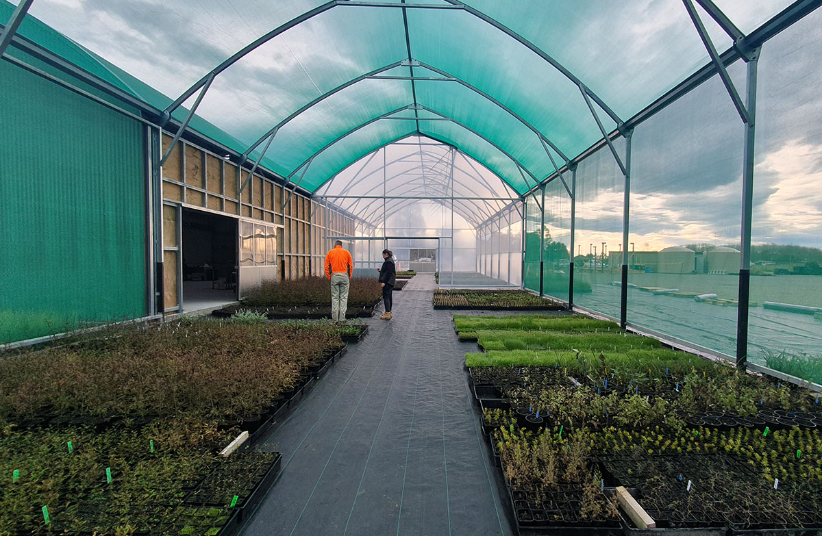
- a nursery established by Te Rūnanga o Arowhenua with 2,000 m2 of tunnel houses and 180,000 plants growing
- native vegetation transition sites developed beside the river
- 58 ha of weeds beside the river returned to the braid plain
- a seed-source area established
- sustained stoat control with 4,150 traps from the coast to the Havelock River
- restoration projects established at cultural and ecological sites
- work with local farmers to protect waterways.
Image gallery
-
Karl Russell Arowhenua kaumatua advising on wetland restoration Image: | DOC

-
An eel is visible is visible at restoration work at Ōtakitane /McKinnon's Creek Image: Environment Canterbury ©

-
Arowhenua Native Nursery in Temuka is growing eco-sourced plants for the restoration. Image: Environment Canterbury ©
![]()
-
17,000 eco-sourced native plants have been planted at Ōtakitane/McKinnon's Creek by Te Kete Tipuranga O Huirapa Image: Environment Canterbury ©

-
Tenehaun Station Image: | DOC


Six priority locations
Six sites in the lower catchment have been investigated for restoration. A detailed mahinga kai (food gathering) and ecological restoration plan has been prepared for each site. The work is intended to increase the mauri (life force) and the diversity and abundance of native plants and animals found at each site.
The integral role of Te Rūnanga o Arowhenua as kaitiakitanga (caretakers) of the river is respected and incorporated throughout the project and its planning. The work is supported by Jobs for Nature and Environment Canterbury’s Climate Resilience and Flood Protection funding.
1. Hāpua
This 60ha site consists of two areas at the river mouth, which include a narrow coastal lagoon, gravel islands, spring-fed streams, and riverside and gorse-covered land.
Work will include ecological surveys, restoration planting and understanding the site’s hydrological and geomorphic processes to safeguard it from future sea level rises and climate change.
Mahinga kai and ecological restoration plan for Rangitata hāpua (PDF, 6,184K)
2. Coldstream reserve 1
This 86 ha site is a river terrace on the river’s northern side. It was once a significant part of the river and would have provided habitat for native fish, insects and birds. Now, it is mainly covered in weeds such as poplar, willow, gorse, broom and blackberry.
This project will research the feasibility of returning it to a dynamic braided river habitat containing streams and wetlands or restoring the dryland and riparian native forest and wetland habitats. Appropriate surveys, restoration planting, pest control and other actions will follow.
Mahinga kai and ecological restoration plan for Coldstream 1 (PDF, 4,702K)
3. Coldstream 2
This 132 ha site is a low river terrace on the river’s northern side. It is part of the Rangitata River Conservation Reserve administered by DOC.
This area was once relatively open and connected to the active floodplain by dry river channels. It contains remnants of low terrace grassland and scrubland communities, which are some of last on the Canterbury Plains. It is currently leased out for grazing sheep.
Mahinga kai and ecological restoration plan for Coldstream 2 (PDF, 4219K)
4. Ealing Springs
This 211 ha site is a terrace on the river’s flood plain. It contains the spring-fed Ealing Spring Creek and its channels, that spread into areas of wetland. Gamebird hunting is popular in this area and it is recognised as a salmon spawning site.
Project goals include managing threats to the site, building access tracks, gaining recognition as part of the whole river and ensuring it continues to provide recreational opportunities.
Mahinga kai and ecological restoration plan for Ealing Springs (PDF, 3,585K)
5. Ōtakitane/McKinnon’s Creek
This site is a 500m-long portion of spring-fed stream 2km above the river mouth that crosses 2 dairy farms. It includes Kawauraki, a culturally significant site in the head of the system and has a salmon hatchery in the lower reaches.
Project goals are to fence off and plant the southern section of the site, improve and maintain water quality and manage threats to the site.
Mahinga kai and ecological restoration plan for McKinnons Creek (PDF, 4,318K)
6. Main river from gorge to mouth
This project covers 60 km of river and includes braid plains, spring-fed creeks and wetlands, historical river paths, stone fields and river margins.
Project goals are to:
- restore and protect the braid plain
- survey, monitor and carry out research to improve the management of the river and the species the area supports
- ensure flood protection works align with ecological and cultural aspirations
- develop a network of habitats and tracks to connect mountains to sea.
Mahinga kai and ecological restoration for Main Stem (PDF, 3,560K).
Jobs for Nature funding
In 2021, the catchment received two Jobs for Nature initiatives through Ngā Awa:
- an $8.7 million project focussed on the lower Rakitata, managed by Te Rūnanga o Arowhenua
- a $7.3 million project focussed on the upper Rakitata, managed by the Upper Rangitata Gorge Landcare Group.
The funding has enabled significant progress on riverside fencing, wetland restoration, pest trapping and planting natives, including establishing a native plant nursery.
Funding for pest and weed control was also provided by Toitū Te Whenua Land Information New Zealand (LINZ) as part of its biosecurity programme.
Riverside planting for flood protection
Environment Canterbury is leading planting work on land beside the river (berms) to create buffer zones that slow floodwaters and reduce erosion. They will also increase habitat and biodiversity, decrease weeds and in time act as corridors that allow native species to move up and downstream.
Work to March 2022 included 55km of riparian fencing, 31,000 plants placed in the ground on more than 5 high country stations, 1,700 ha of predator control and 943ha of weed control.
Read more about the Environment Canterbury - Planting and berm transition work.
Upper catchment restoration work
The upper Rakitata River contains some of the South Island’s best known high country stations such as Mt Peel, Erewhon and Mesopotamia. Threatened birds breed in this area, so reducing the number of predators and keeping the river braids free of woody weeds is important for their conservation.
The Upper Rangitata Gorge Landcare Group began landscape-scale weed control in the upper catchment in 2000, coordinating the work across landowners, agencies and councils. Jobs for Nature funding is supporting this work with farmers, landowners, DOC and other agencies in partnership. Activities include fencing out stock, restoring wetlands, trapping pests and growing and planting eco-sourced and culturally important natives.
Toitū te Whenua Land Information New Zealand also provides funding and leads additional joint agency weed control work in the upper catchment.
Central South Island Fish & Game in collaboration with landowners, has managed a weed control programme at Tui wetland and Deep stream since 2006. This area provides habitat for many native species and spawning habitat for chinook salmon.
Funding from DOC and Environment Canterbury also is supporting the development of a more effective approach to weed control and allowing it to be expanded to parts of the lower river.
Peel Forest landfill remediation
Timaru District Council is completing work to prevent rubbish from a legacy landfill site entering the Rakitata River.
The Peel Forest Landfill operated from 1963 to 2004. A large flood in 2019 caused erosion along a river terrace and cliff face, exposing surface rubbish and debris. The flooding also caused the main river channel to move closer to the landfill site. So, Timaru District Council and Environment Canterbury carried out temporary work to redirect the river to prevent further erosion.
Floods in July, August and October 2022, however, exposed more surface waste outside the main landfill area and washed away a large proportion of the temporary remedial work.
In late 2022, Timaru District Council removed the exposed rubbish and moved about 40,000 tonnes of river shingle to redirect the river’s southern channel away from the landfill.In January 2023, measures to manage stormwater runoff from the surrounding paddocks were introduced to reduce the risk of flood damage to the site. The landfill was also sampled to characterise the waste ahead of its removal.
The council’s 2024–25 Annual Plan has budgeted to remove all waste from the landfill, which will happen in 2024.
Public land management study
Public land tenure in the lower river catchment was researched to align land management across several agencies. This information provides an opportunity to manage public land in and around braided rivers in Canterbury based on outcomes rather than tenure. The Rakitata River would be a pilot site for the management practices.
Increasing flood and climate resilience
Severe flooding of the Rakitata River in 2019 caused major damage to roads, rail, electricity supply, farms and other infrastructure in the catchment. Bulldozers made emergency embankments, which were followed by new stopbanks, gravel groynes and strengthened rock groynes along the south bank of the river.
In 2023, work to increase climate resilience and protect communities from future flood events was begun, supported by Kānoa - Regional Economic Development and Investment Unit. This major project is using natural structures and enhancements that support the community’s vision for a healthy river and providing local job opportunities.
Read more about Rangitata 2019 flood recovery