Kaikōura/Te Tai-o-Marokura marine management review
A 10-year review of the Kaikōura Marine Area management measures is being undertaken as required by the Kaikōura (Te Tai ō Marokura) Marine Management Act 2014 (Section 8).
The review is to assess the ‘operation and effectiveness’ of those management measures.
On direction of Ministers, DOC and Fisheries New Zealand are now carrying out the review, which includes public consultation and involvement of the Kaikōura Marine Guardians and local tangata whenua, Te Rūnanga o Kaikōura.
As part of the review, DOC and Fisheries New Zealand hired an external consultant to evaluate the Kaikōura Marine Guardians, a local advisory committee. DOC and Fisheries New Zealand will consider the consultant’s findings and recommendations as part of developing advice and recommendations to Ministers.
Public consultation closed on 11 November 2025. Submissions will inform a report for the Minister of Conservation and the Minister for Oceans and Fisheries. DOC and Fisheries New Zealand will publish this report on their websites at the conclusion of the process.
In 2014, the Kaikōura (Te Tai ō Marokura) Marine Management Act 2014 was passed to implement key elements of the Kaikōura Marine Strategy.
The Act established management measures to ‘assist the preservation, protection, and sustainable and integrated management of the coastal and marine environment and biological diversity of Te Tai o Marokura’ – the Kaikōura Marine Area. This area covers from Clarence Point (just north of the Waiau Toa/Clarence River) to the Conway River and out to 12 nautical miles.
Kaikōura/Te Tai-o-Marokura marine management map (PDF, 3,359K)
The Kaikōura-specific management measures are below.
Kaikōura Marine Guardians
The Guardians provide advice on biosecurity, conservation or fisheries matters relating to the Kaikōura Marine Area, to Ministers or others exercising statutory powers in the area. They are appointed to represent the interests and areas of expertise of Te Rūnanga o Ngāi Tahu, the Kaikōura community, biosecurity, conservation, education, environment, fishing, marine science and tourism.
For more information, see Kaikōura Marine Guardians: Statutory & advisory bodies.
Hikurangi Marine Reserve
Hikurangi Marine Reserve encompasses part of the Kaikōura Canyon and connects to the coast south of Kaikōura township. It covers an area of approximately 10,395 hectares, and is 1,000 meters deep, making it New Zealand’s largest and deepest mainland marine reserve.
Hikurangi Marine Reserve is home to diverse coastal and deepwater ecosystems. The coastal portion protects a representative slice of Kaikōura’s rocky reef habitats and their species. The canyon has very dense and diverse populations of seafloor invertebrates. The canyon also supports an important feeding area for the various seabirds, seals, dolphins and whales that Kaikōura is renowned for. Long term monitoring within the Hikurangi Marine Reserve and in surrounding site has assessed the status and trend of indicators, including key invertebrate and fish species.
For more information, see the monitoring report on key species in the Hikurangi Marine Reserve.
Recreational and tourism activities that do not disturb the area are allowed, while all marine life and habitats within the marine reserve are totally protected:
- no fishing, netting, hand gathering, taking or killing of marine life
- no polluting, disturbance or damage of marine life or the seabed
- no removal of any natural material from the marine reserve.
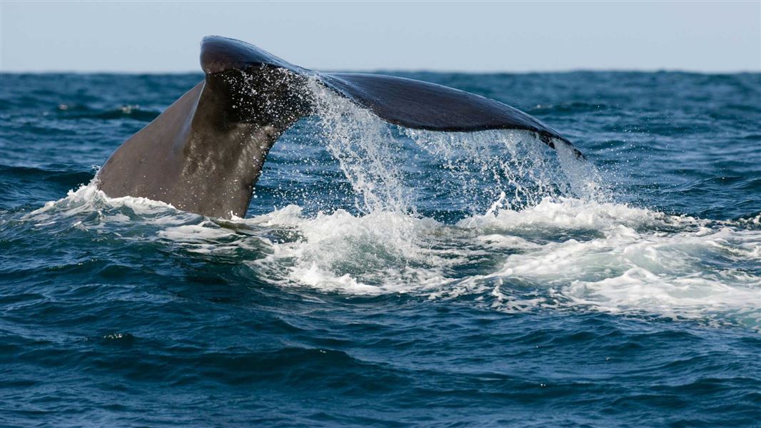
Te Rohe o Te Whānau Puha Whale Sanctuary
Te Rohe o Te Whānau Puha Whale Sanctuary covers approximately 4,700 square kilometers of the coastal and offshore environment near Kaikōura. It extends from the northern boundary of the Kaikōura Marine Area at Clarence Point, south to near Gore Bay and offshore to a maximum distance of 56 km.
The sanctuary provides greater protection for whales and other marine mammals by restricting seismic survey activities. This reduces the potential impacts of these activities, which could include disruption to communication or feeding, or physical trauma. Seabed mining (other than petroleum mining) is also prohibited within the sanctuary.
Ōhau New Zealand Fur Seal Sanctuary
Ōhau Point, north of Kaikōura, is a significant breeding colony for kekeno/New Zealand fur seals. An 800 m length of the shoreline and the inter-tidal area around Ōhau Point is encompassed within the fur seal sanctuary.
Kekeno can be disturbed by humans wandering through their land habitat. This can cause them to become aggressive which can pose a risk to humans. The sanctuary prohibits public access, so the seals can have space to rest and for pups to feed, without interference. The seals are able to be viewed from a safe distance from the viewing platform at Ōhau Point and along the roadside walkway that runs along the length of the sanctuary.
Mangamaunu Mātaitai, Oaro Mātaitai and Te Waha o te Marangai Mātaitai
These three mātaitai reserves were established to recognise and provide for traditional food gathering areas. Mātaitai reserves are closed to commercial fishing and may have bylaws affecting recreational and customary fishing.
For more information on these areas, see Customary fisheries management areas, rules, and maps | NZ Government.
Te Taumanu o Te Waka a Māui Taiāpure and Oaro-Haumuri Taiāpure
Two taiāpure, or local fisheries of special significance, were established. In taiāpure, all fishing can continue until changes to fishing regulations are made.
For more information on these areas, see Customary fisheries management areas, rules, and maps | NZ Government.
Amended recreational fishing regulations
Reduced bag limits and other restrictions apply for a number of commonly targeted finfish, shellfish, seaweed and rock lobster species within the Kaikōura Marine Area.
For up to date information on the fishing rules for this area, see Kaikōura area fishing rules | NZ Government.