
Application for a lease by Porirua Adventure Park Limited Partnership
Introduction
Have your say on an application by Porirua Adventure Park Limited Partnership for a lease concession at Rangituhi / Colonial Knob Scenic Reserve, Porirua. Submissions closed 19 October 2018.This application is notified under section 17SC of the Conservation Act 1987. The Minister of Conservation has received an application for a lease / licence and easement for a term of 30 years.
Application details
Applicant
Porirua Adventure Park Limited Partnership
Location of proposed activity
Public conservation land – Rangituhi / Colonial Knob Scenic Reserve, Porirua.
Map reference
Gondola – Intersecting the following coordinates. NZTM: (X:1,752,881 Y: 5,442,547) (X:1,752,821 Y:5,442,959) and (X:1,752,781 Y:5,443,233).
Summary of proposal
The Applicant, Porirua Adventure Park Limited Partnership, is seeking the necessary resource consents from Porirua City Council and Greater Wellington Regional Council and a concession from DOC to establish and operate an adventure park being ‘The Porirua Adventure Park’.
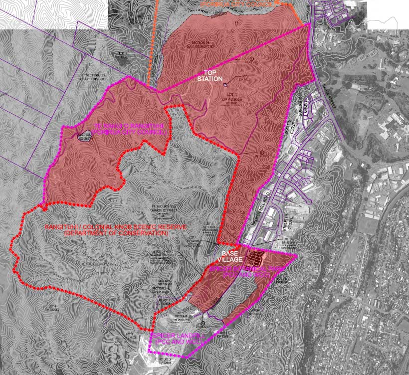
The application site is Spicer Botanical Park, Rangituhi / Colonial Knob Scenic Reserve, Te Rahui o Rangituhi (formally ‘Colonial Knob Parklands’), the Porirua Scenic Reserve, the Spicer Botanical Park and a portion of the Spicer Landfill.
The application site is identified as the purple outlined area in the below map and the Rangituhi / Colonial Knob Reserve, the only portion of the site subject to the DOC concession application is highlighted red.
Note: The majority of the Porirua Adventure Park, approximately 90% of the proposal, is on land managed by Porirua City Council and is not on public conservation land.
The Adventure Park proposal comprises the following key components:
- The establishment and operation of recreational activities including walking, mountain biking and a surf simulator;
- A Base Station compound at Spicer Botanical Park containing an operations building, café, a surf simulator, a demonstration and bike repair centre, toilets, changing rooms, administration, and the gondola station and gondola maintenance station;
- A Top Station compound at Te Rahui o Rangituhi containing a café, bathroom facilities, a covered walkway, a designated helicopter landing area and a service shed;
- A gondola comprising two stations and nine towers that enables access from the Base Station to the Top Station;
- Uphill and downhill mountain bike trails that comprise a combination of trails already consented under an existing Porirua City Council consent and new trails proposed in this application;
- New walking trails and upgrading and extension of existing walking trails to an accessible standard including the creation of a loop trail around the Department of Conservation redundant water reservoir;
- A zipline extending from below the proposed Top Station to the land within the Spicer Landfill designation. The line comprises two lines accessible via two steel tower structures;
- A new carpark with bus bays, a helipad and a hanger within the Spicer Landfill site that is currently utilised as a landfill ‘borrow area’;
- Helicopter movements for both emergency and operational / commercial purposes to and from helipads located at the base station and top station;
- Upgrading of existing vehicle and accessible access routes within Spicer Botanical Park;
- Vegetation disturbance, trimming, and clearance associated with building, gondola and trail construction;
- Earthworks and construction works;
- Signage; and,
- A number of remediation and mitigation measures recommended by the project team including the installation of a flood protection berm to the west of the base station compound, mitigation planting, landscape amenity planting, ecological monitoring and pest and weed control.
The proposed hours of operation for the proposed Adventure Park will be 365 days a year as follows:
- New Zealand Daylight Saving Time - Winter: 10 am to 5 pm 7 days a week, Summer: 10 am to 9 pm 7 days a week.
- For temporary events held at the Top Station café it is proposed that hours of operation extend to 12 pm (midnight). It is anticipated that up to 15 events will take place at the Top Station café in the summer day light saving period.
The design of the Base Station and Top Station compounds and trail network will enable the use of the proposed Adventure Park for a variety of events for non-biking and biking based events. It is proposed that consent conditions manage the number, duration and operation of events at the Adventure Park.
The resource consent and assessment of environmental effects is accompanied by a number of technical reports including an ecological assessment, assessment of landscape and visual effects, hydrological and hydraulic evaluation, a geotechnical report, a traffic assessment and a cultural impact assessment.
Concession applied for
In total, works across the reserve (excluding the pine clearance works) proposed as part of the establishment of the Adventure Park operation, amounts to 0.27% of the Rangituhi / Colonial Knob Scenic Reserve site area.
Lease area
- The construction, operation, and maintenance of two of the proposed gondola towers (towers 1 and 2) within the Reserve. The vegetation clearance works are proposed across an area of 450m2, which represents 0.04% of Rangituhi / Colonial Knob Scenic Reserve.
- The gondola tower construction and final towers will take up an area of 180m2 (90m2 for each tower), which represents 0.01% of the Reserve (that has a total area of approximately 128 hectares).
Licence area
- The trails proposed within the reserve are highlighted in the attached document, Appendix Three - Trail Table. In total, 2,328m of new walking and downhill trails are proposed in Rangituhi / Colonial Knob Scenic Reserve. This amounts to 10% of the new trails proposed as part of the Adventure Park.
- Extension and upgrading of the existing Spicer Link Trail (‘Trail 7 – Reservoir Accessible Loop’) to create a loop trail around the existing reservoir. Within the Reserve, with a length of 418m and a maximum width of 1.2m, this trail represents 0.038% of the Reserve.
- Construction, use and maintenance of a portion of proposed Trail 14 (‘the Euro Descent’). Within the Reserve, with a length of 1,697m and a maximum width of 1.2m, this new trail represents 0.16% of the Reserve.
- Construction, use, and maintenance of a short section of proposed new Trail 16 (‘the Downhill Loop’). Within the Reserve, with a length of 517m and an average width of 1m, this new length of trail represents 0.039% of the Reserve.
- Construction, use and maintenance of a small 18m long portion of proposed Trail 21 (Downhill Race Track).
- Construction of a portion of existing trails Spicer Link (Trail 28) and Spicer to Tumeke connection (Trail 29) to an accessible standard. Together these trails will be 368m in length, and, given the maximum width of 1.2m will comprise a total of 441.6m2, representing 0.034% of the Reserve.
Easements (airspace) area
- The gondola spanning (airspace only) of 353m over DOC land. The corridor is 20m wide and will therefore span over a total area of 7,060m2, being 0.5% of the Reserve. 353m is made up of 22m over Lot 2 DP 52896 and 331m over Pt Section 155 Ohariu District.
- The zipline spanning (airspace only) of 447m over the Reserve. The corridor is 6m wide and will therefore span over a total area of 2,682m2, being 0.2% of the Reserve. 447m is made of of 62m over Lot 2 DP 52896 and 385m over Pt Section 155 Ohariu District.
- Minor pine clearance works within the corridor that spans between towers 5 & 6 over Rangituhi / Colonial Knob Scenic Reserve to ensure safe clearances are provided between the top canopy and the gondola infrastructure for that portion of the corridor route that spans the Reserve.
Porirua City Council consents sought
The following consents are sought from Porirua City Council for the Porirua Adventure Park across all of the land parcels collectively identified as ‘the application site’ in the map above:
Public Open Space Zone (Spicer Botanical Park, Rangituhi / Colonial Knob Scenic Reserve and Porirua Scenic Reserve)
- Discretionary (Rule D7.1.4(I)) - Recreation activities which contravene permitted activity standards.
- Discretionary (Rule D7.1.4(I)) - The construction of buildings and structures which contravene permitted activity standards
- Discretionary (Rule D7.1.4(I)) - The construction and maintenance of boardwalks, walkways, footpaths, cycle ways, access ways and car parks, which contravene riparian setback (D7.2.1); and, maximum earthworks limits (D7.2.1).
Rural Zone (Te Rahui o Rangituhi)
- Discretionary (Rule D4.1.1(iii) - New buildings in a Landscape Protection Area;
- Discretionary (Rule D4.1.4(i)) - Recreational and retail activities and the helicopter operation; and,
- Discretionary (Rule D4.1.4(i)) - Construction, use and maintenance of bike and walking trails.
Industrial Zone (Spicer Landfill)
- Discretionary (Rule D2.1.4) – For infringements to the carpark, earthworks and yard permitted activity standards; and
- Discretionary (Rule D2.1.4(i) – Helicopter operation
Department of Conservation land
Note: Submissions to the Department should only consider the effects of the specific activities on Department of Conservation land. Activities on Porirua City Council Land should not be considered. The Department has provided the other ancillary documents to provide a holistic picture of the Porirua Adventure Park in its entirety.
Rangituhi / Colonial Knob Scenic Reserve (DOC land)
As labelled on the map below. Note: Red shaded areas are Porirua City Council Land.
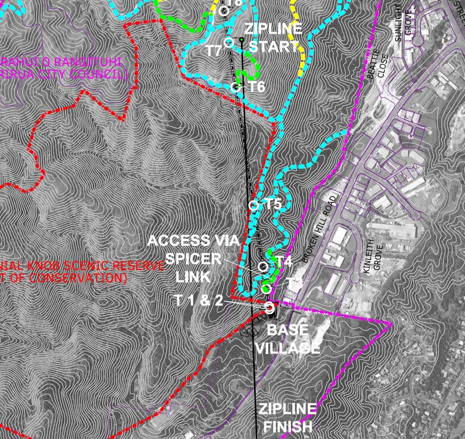
Map of Gondola and Zip Line path
Submissions should consider that only gondola towers 1 & 2 are on the Reserve.
The black lines stretching across DOC land represent the gondola and zipline cables. An easement has been sought for the airspace occupied by these cables.
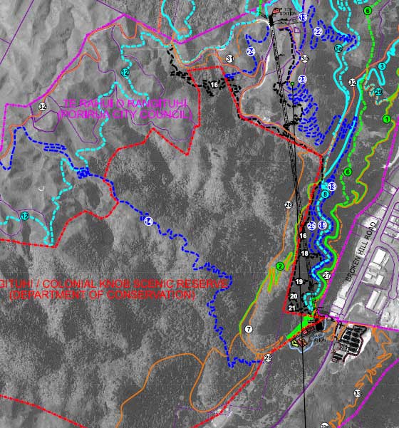
Map of cycle and walking tracks
Please see Application document ‘appendix 5 – Application Drawings’ for greater detail on which trails are on DOC land.
How to submit
Any person or organisation may make a submission in writing to the Director-General on the proposal. The submission must be made on a submission form – download a copy or get one from your local DOC office.
Comment submission form (Word, 236K)
You may make a submission by sending a written or electronic submission to:
Director-General
Department of Conservation
Private Bag 3072
Hamilton 3240.
Attention: Daniel Lincoln, Permissions Advisor
Email: permissionshamilton@doc.govt.nz
Submissions close on Friday 19 October at 5 pm. Once submitted, submitters' information is subject to the Official Information Act 1982 and may be released under that Act. If you wish to keep any part of your submission confidential, you need to state this in writing when making your submission.
Any person or organisation wishing to be heard in support of his/her submission, must request (within that submission) an opportunity to appear before the Director-General.
DOC comment regarding publicly notified applications
The Minister of Conservation has made no determination regarding the suitability of this proposed concession on public conservation land. This public notification should not be interpreted as an intention on the part of the Minister of Conservation to grant the proposed concession.
Hearing details
If a hearing is required, it is likely to occur on the week starting 29 October 2018.
Decision
No details at this point.
Application documents
Supporting application documents (Zip,139,000K) Note: this is a very large file